
Floodplain Management
The Bureau of Meteorology website provides daily River Height Bulletins (external link) across Victoria.
River regulation in the Wimmera catchment has altered not only the timing of floods but also the size and frequency of flooding. Creeks that formerly ran dry for extended periods continue flowing while others that were more often wet now remain dry, except for exceptionally high floods. These changes affect not only adjacent floodplain vegetation, but also aquatic fauna that may be dependent upon certain flooding regimes. Modified flooding regimes have a significant impact on each bioregion’s waterways, notably the Outlet Creek system, which together with the terminal lakes and Lake Albacutya forms part of the Wimmera Heritage River system (DNRE, 1997).
 Wimmera River |
Related Links
A wide range of flooplain data can be accessed via MapShare (external link) in the form of an interactive map, using information from DEPI. The Catchment and Water Mapper section provides information on themes such as rivers, 1 in 100 year flood, floodways, and river basins.
A Floodplain Wetlands Management Strategy (external link) is also available for the Murray-Darling Basin region (MDBMC, 1998). Other reports (produced by the Wimmera Catchment Management Authority (external link) relevant to floodplain management in the Wimmera include:
WCMA, Wimmera Water Quality Strategy (In draft). Horsham.
WCMA (I999). Regional Floodplain Strategy. Horsham.
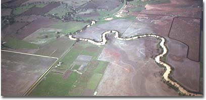
Flooding in drainage depressions near Longerenong during the wet winter of 1973. Longerenong College is in the top left of the photo. Darlot Swamp is in the bottom right. These drainage depressions are part of the Wimmera River system.
References
Department of Natural Resources and Environment (the former DNRE) (1997). Victoria’s Biodiversity: Directions In Management, Melbourne.
Murray-Darling Basin Ministerial Council (MDBMC) (1998). Floodplain Wetlands Management Strategy for the Murray-Darling Basin, Murray-Darling Basin Ministerial Council, Canberra.
Wimmera Catchment Co-ordinating Group (1992). Wimmera River: Integrated Catchment Management Strategy. Final Report, National Soil Conservation Program, Victoria.
WCMA, Wimmera Water Quality Strategy (In draft). Horsham.
WCMA (I999). Regional Floodplain Strategy. Horsham.
© State of Victoria (Agriculture Victoria) 1996 - .

This work, Victorian Resources Online, is licensed under a Creative Commons Attribution 4.0 licence. You are free to re-use the work under that licence, on the condition that you credit the State of Victoria (Agriculture Victoria) as author, indicate if changes were made and comply with the other licence terms.
The licence does not apply to ‘branding’ or some ‘images or photographs’ that may be owned by third parties. We ask you to seek prior approval to use images using the VRO feedback form. Access to higher quality images can also be provided on request.
This page was last updated on .