
Perry (Py)
|
|
 |
Pleistocene aeolian sands.
Landform
Longitudinal dune fields. These dunefields form a discontinuous mantle over the Pleistocene terraces east of Blackall Creek and become more extensive east of Perry River. The sand dunes in these areas were most likely formed from sands blown from these streams by the prevailing westerly winds, particularly during periods of aridity associated with past glacial periods.
Land Use
Most of the dunes have been cleared and used for grazing. However, large areas of remnant vegetation occur east of the Perry River and north of Boundary Road near Bengworden.
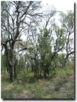 Example of vegetation in the Perry mapping unit near Providence Ponds. | Original Vegetation Ferny and heathy woodland with stringybark, peppermint and saw banksia (Banksia serrata). Bracken and prickly broom heath are common understorey species (Aldrick et al., 1992). Previous Maps and Reports The Perry Land System as described by Aldrick et al. (1992). |
Soils
The soils are deep acidic sands with an organic matter enriched topsoil and a bleached subsoil. Generally a layer of organic and/or iron-cemented sand in the form of 'coffee rock' or concretions occurs in the deep subsoil. These soils are referred to as Podosols using the Australian Soil Classification. As mentioned earlier, these sands mantle an older Pleistocene alluvial plain, and as a result the sands are generally underlain by sodic clays at variable depths. This map unit commonly forms an association with the Fernbank map unit.
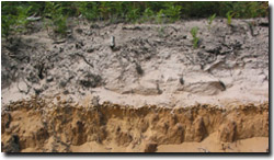 A Podosol near Providence Ponds. | 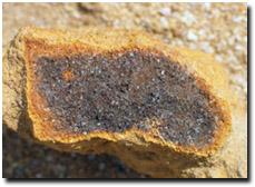 An example of coffee rock from Podosol near Providence Ponds. |
Chemical and Physical Analysis
No analyses have been carried out on any of these soils within the study area but results from one profile 20 km north of Stratford are given by Aldrick et al. (1992).
© State of Victoria (Agriculture Victoria) 1996 - .

This work, Victorian Resources Online, is licensed under a Creative Commons Attribution 4.0 licence. You are free to re-use the work under that licence, on the condition that you credit the State of Victoria (Agriculture Victoria) as author, indicate if changes were made and comply with the other licence terms.
The licence does not apply to ‘branding’ or some ‘images or photographs’ that may be owned by third parties. We ask you to seek prior approval to use images using the VRO feedback form. Access to higher quality images can also be provided on request.
This page was last updated on .