
5.3.1 Groundwater discharge depressions and associated lunettes, north east - south west ridges, gypseous dunes and sandplains
5. North Western Dunefields and Plains (DP)
5.3 Depressions
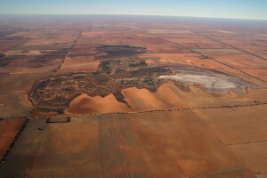
| Below 40 m elevation in the Raak and Noora Depressions, and 60 m in the Tyrrell Depression, landscapes have been modified by groundwater discharge. Blanchetown Clay has been salinised, then deflated to form landform complexes known as “boinkas”. These are mostly large but in some districts they are scattered and only 1-2 km across, particularly to the north of Lake Timboram and to the south and east of Ouyen. Salinas occupy the lowest sites where salts and gypsum have accumulated in muds derived from dust and lacustrine deposits. Salinas occupy most of the lake beds in the Tyrrell Depression, and about half on the Raak Plain and the Noora boinkas. However they are infrequent in the boinkas to the north of Cowangie and Underbool, except in the Pink Lakes area. Plains with halophytic shrubs occur where depth to groundwater is a little greater. The very salt-tolerant Samphire (Halosarcia spp.) fringes the salinas and occupies the lowest levels to the north of Cowangie and Underbool when salinas are absent. At yet higher elevations above the water table there are Saltbush (Atriplex spp.) shrublands which often alternate with Samphire in a complex pattern. Raised sandplains are widespread on the Raak Plain where they alternate with north west - south east ridges, salinas and plains with halophytic shrubs. The soils are reddish-yellow sands with reddish clayey sand subsoils, apparently derived from sand dunes blown in from the west. In the north-west corner of the Raak Plain there is a remnant of unit 5.1.1 in which linear dunes are dominant. Subsequent lake-full conditions have reworked the sands to produce the raised sandplains with smooth boundaries. Grasslands predominate and these were grazed by livestock for many years. There are fringing trees such as pine, belah and mallee eucalypts on the red sands, particularly along the eastern margin of the plain. | 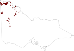 |
Gypseous dunes occur in most boinkas, and are particularly widespread to the north of Cowangie and Underbool. The low mounds contain layers of sand, copi (powdered gypsum), crystalline gypsum and sometimes limestone. The dunes have been sculptured by water, producing smooth boundaries which may be irregular. Vegetation is mostly mallee, saltbush shrubland or a mixture of the two.
Lunettes often flank lake beds, particularly in the Tyrrell Depression and in boinkas scattered around Ouyen. The original vegetation is more akin to that of the surrounding dunefields, for example mallee scrub and pine-belah woodlands, although the large lunette flanking Lake Tyrrell supports a Bluebush (Maireana spp.) shrubland. Soils show varying degrees of development according to age of deposits, ranging from young grey friable clays (Vertosols) to red and yellow Sodosols.
Boinkas are particularly susceptible to erosion and to increased surface salinity upon disturbance. Many halophytic shrublands have degenerated through increased surface salinity, particularly the Samphire. Degeneration results directly from grazing and indirectly through rising groundwater levels when the original vegetation is removed from higher lands. Farmed texture contrast soils on lunettes have suffered extreme wind erosion on western slopes, exposing sodic clays susceptible to water erosion. Severe gullying ensues. Such severe gullying is rarely found on other landforms in the region.
© State of Victoria (Agriculture Victoria) 1996 - .

This work, Victorian Resources Online, is licensed under a Creative Commons Attribution 4.0 licence. You are free to re-use the work under that licence, on the condition that you credit the State of Victoria (Agriculture Victoria) as author, indicate if changes were made and comply with the other licence terms.
The licence does not apply to ‘branding’ or some ‘images or photographs’ that may be owned by third parties. We ask you to seek prior approval to use images using the VRO feedback form. Access to higher quality images can also be provided on request.
This page was last updated on .