
AB1 Altona, Kooringal Golf Club - Sand Ridges
|
This information has been developed from the publications:
|
| Location | Altona Bay - 070054. City of Altona. Kooringal Golf Club and EPA. Vehicle Testing Station 2 km west of Altona. | 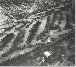 AB1 - Remnant sand ridges and swales, Kooringal Golf Club, Altona. |
| Access | Queen Street and The Esplanade. | |
| Ownership | Crown land. | |
Site Description | The site is a remnant of a formerly extensive series of shelly sand ridges that lay parallel to the coast between the mouth of Kororoit Creek and Skeleton Creek. The ridges consist of well-stratified shell beds including many unbroken forms lying with the convex side uppermost. This position of repose indicates that they were deposited on the sea floor and not thrown up by storm waves. The ridges rose to 3 m above high tide level and extended over 1 km inland, but they have been much modified by residential and other developments at Altona. At the golf course, the ridges have been retained as treed areas separating the fairways which generally lie along the swales (lower areas between ridge crests). | |
The ridge crests are flattened and this configuration, along with the lobate branching patterns of some ridges, suggests they originated as sea floor ridges and spits rather than as wind-blown or storm wave ridges. If this is the case, their elevation would indicate they were formed at a time when sea was level 1 to 3 m higher than at present. Radiocarbon dating of shell material has given ages of 5,000 to 6,000 years - hence the site has been proposed as evidence that the sea stood at a higher level in the mid-Holocene. | ||
Significance | State. The area enclosed the last remnants of the Altona ridges and the present alignment of the golf course preserves their general character, although in a modified form. The ridges are important in the analysis of sea level changes over the last few thousand years as their composition and form indicates they were formed on the sea floor. The site is one of several around Port Phillip Bay that indicate higher Holocene sea levels, and is one of a small number of such mapped and dated localities on the Victorian coast. | |
Management | Class 2. Maintenance of the golf course in its present pattern would preserve the general form of the sand ridges. The pattern is also well represented in the area used by the EPA but extensions to facilities here could fundamentally alter the character of the sand ridges. Use of the area as a park or open space facility would be more appropriate in the long term to protect the topography. Engineering works or building construction on these areas would destroy the essential character of these significant features. | |
References | Jutson, J.T. (1931). Erosion and Sedimentaion in Port Phillip Bay, Victoria. Proc. R. Soc. Vict. 43: 164-174. Hills, E.S. (1949). The Question of Recent Emergence of Port Phillip Bay. Proc. R. Soc. Vict. 54: 79-92. Bowler, J.M. (1966). Port Phillip Survey 1957-1963: Geology and Geomorphology. Memoirs Nat. Mus. Vic. 27: 19-67 | |

© State of Victoria (Agriculture Victoria) 1996 - .

This work, Victorian Resources Online, is licensed under a Creative Commons Attribution 4.0 licence. You are free to re-use the work under that licence, on the condition that you credit the State of Victoria (Agriculture Victoria) as author, indicate if changes were made and comply with the other licence terms.
The licence does not apply to ‘branding’ or some ‘images or photographs’ that may be owned by third parties. We ask you to seek prior approval to use images using the VRO feedback form. Access to higher quality images can also be provided on request.
This page was last updated on .