
Spring Hill (Balliang East)
|
This information has been obtained from the report: Eruption Points of the Newer Volcanic Province of Victoria by Neville Rosengren. This report was published in 1994 and was prepared for the National Trust of Australia (Victoria) and the Geological Society of Australia (Victorian Division). The review of eruption points was based on an earlier unpublished manuscript Catalogue of the post-Miocene volcanoes of Victoria compiled by O P Singleton and E B Joyce (Geology Department, University of Melbourne 1970). |
| 37 46 30S 144 28 30E (external link); 7722-2-1 (Balliang Creek) & 7722-1-2 (Lerderderg) 770195 to 778161. 11 km SE of Bacchus Marsh. Spring Hill Road. Ballan Road. Exford Road. | 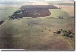 Shallow craters on northern slope of Spring Hill (Balliang East) | |
Balliang East | ||
Bacchus Marsh | Agriculture, boulder outcrops (many paddocks cleared of stones). | |
Private land: | Lava shield. | |
Type 2: | This is a large site and consists of number of eruption points along a north-south alignment over a distance of 2 km along the crest of a low, broad ridge. The eruptions produced numerous overlapping lava flows building an irregular lava shield with a remnant shallow crater on the northern flank. This pyroclastic deposits are interbedded with lava. The site also encloses two shallow broad craters 10 to 20 m deep with a rim of pyroclastic material. These do not appear to have given rise to lava flows and may have resulted from steam or gas explosions breaching a thin lava crust. | |
160+m; 20m. | ||
Regional: | A good example of the volcanicity that produced much of the Werribee Plains. This is an example of a broad low angle eruption point typical of that built by very fluid lavas. Pyroclastic eruptions are unusual on the Werribee Lava Plains. These are good regional examples of small explosion craters during the last phases of volcanicity in this area. The crates are subtle landforms and their identity would be easily lost if the area was covered by residential subdivision. | |
Class 2: | Roadworks and buildings on the low angle slopes destroys the visual unity of sites of little relief such as this one. | |
References: | Coulson, A. 1938. The basalts of the Geelong district. Proceedings of the Royal Society of Victoria 50, pp. 251-257. Condon, M.A. 1951. The geology of the lower Werribee River, Victoria. Proceedings of the Royal Society of Victoria 63, pp. 1-24. Ollier, C.D. & Joyce, E.B. 1964. Volcanic physiography of the Western Plains of Victoria. Proceedings of the Royal Society of Victoria 77, pp. 357-376. Roberts, P.S. 1984. Explanatory notes on Bacchus Marsh and Ballan 1:50 000 geological maps. Geological Society of Victoria Report 76. | |

© State of Victoria (Agriculture Victoria) 1996 - .

This work, Victorian Resources Online, is licensed under a Creative Commons Attribution 4.0 licence. You are free to re-use the work under that licence, on the condition that you credit the State of Victoria (Agriculture Victoria) as author, indicate if changes were made and comply with the other licence terms.
The licence does not apply to ‘branding’ or some ‘images or photographs’ that may be owned by third parties. We ask you to seek prior approval to use images using the VRO feedback form. Access to higher quality images can also be provided on request.
This page was last updated on .