
GP27
| Location: Tynong | Aust. Soil Class: Vertic (and Bleached), Magnesic, Grey KUROSOL |
| Northcote Factual Key: Dy 3.41 | Great Soil Group: soloth |
| General Site Description: Pasture paddock | Mapping Unit: Narre clay loam. |
| Landscape Description: Alluvial plain | Geology: Late Pleistocene and recent alluvial deposits (derived from granite hills) |
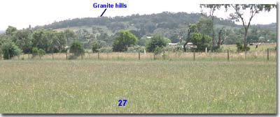 Site GP27 Landscape |
Surface soil:
| A1 | 0-15 cm | Dark brown (10YR3/3); light sandy clay loam; hardsetting surface condition; weak coarse blocky, parting to weak crumb structure; firm consistence moist; pH 5.5: | 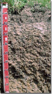 Site GP27 Profile |
| A2 | 15-25 cm | Pale brown (10YR6/3), conspicuously bleached (10YR8/1d) [with some sporadic bleaching]; coarse sandy loam; firm consistence moist; contains a few (5-10%) quartz fragments (2-5 mm in size); pH 5.8; abrupt and wavy change to: | |
| Subsoil: | |||
| B21 | 25-65 cm | Greyish brown (10YR5/2) with brown (10YR5/3) and yellowish brown (10YR5/8) mottles; sandy clay; moderate coarse blocky structure; very firm consistence moist; contains a few (5-10%) quartz fragments (2-5 mm in size); pH 5.3: | |
| B22 | 65-100 cm | Grey (10YR6/1) with yellowish brown (10YR5/8) mottles; heavy clay; strong lenticular structure; contains a few (5-10%) quartz fragments (2-4 mm in size); pH 5.5: | |
| B23 | 100+ cm | Light brownish grey (10YR6/2) with brownish yellow (10YR6/8) mottles; heavy clay; lenticular structure; contains quartz fragments; pH 5.7. | |
Key Profile Features:
- Hardsetting surface condition.
- Bleached subsurface (A2) horizon.
- Strong texture contrast between A2 horizon (11% clay) and subsoil (B21) horizon (33% clay).
- Gritty soil profile throughout.
- Vertic properties (ie. lenticular structure) in deeper subsoil.
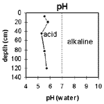 The soil profile is mainly strongly acid throughout. | 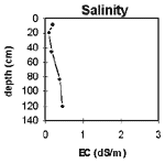 The salinity rating is low throughout the upper profile and becomes medium at depth |
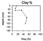 The clay content increases sharply at the A/B horizon boundary. | 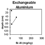 Exchangeable aluminium levels are reasonably low throughout the soil profile. |
Horizon | Horizon Depth | pH water | pH CaCL2 | EC 1:5 | NaCI % | Exchangeable Cations | ExAl mg/kg | Ex Ac meg/100g | Field pF 2.5 | Wilting Point pF 4.2 | Coarse Sand (0.02 -0.2mm) | Fine Sand (0.02 -0.2mm) | Silt (0.02 -0.2mm) | Clay (<0.002mm) | |||
ca | mg | k | Na | ||||||||||||||
meg/100g | |||||||||||||||||
A1 | 0-15 | 5.5 | 4.9 | 0.2 | 3.5 | 2.1 | 0.21 | 0.58 | 13 | 32.3 | 11.3 | 26 | 30 | 22 | 15 | ||
A2 | 15-25 | 5.8 | 4.8 | 0.09 | 1.1 | 1.3 | 0.1 | 0.35 | 18.4 | 5 | 41 | 28 | 21 | 11 | |||
B21 | 25-65 | 5.3 | 4.5 | 0.17 | 1.3 | 4.7 | 0.14 | 0.78 | 61 | 23.8 | 11.6 | 32 | 20 | 15 | 33 | ||
B22 | 65-100 | 5.5 | 4.9 | 0.37 | 0.07 | 0.49 | 8.6 | 0.21 | 2.2 | 15 | 34.6 | 19 | 21 | 15 | 13 | 52 | |
B23 | 100+ | 5.7 | 5.2 | 0.46 | 0.1 | 0.42 | 8.3 | 0.2 | 2.9 | 32.8 | 18 | 21 | 17 | 15 | 47 | ||
Management Considerations:
- Whole Profile
- The soil profile has high levels of exchangeable magnesium in relation to calcium (especially in the subsoil). This may result in nutrient imbalances [eg. calcium deficiency and may also induce potassium deficiency (Baker and Eldershaw 1993)].
Surface (A) Horizons
- The surface soil is hardsetting and has a high fine sand and silt content. When cultivated in a dry condition it will become ‘powdery’ and subsequent rainfall may result in surface sealing occurring. Soils such as these rely to a large extent on organic matter for maintaining aggregation as when wet they are liable to slake. The levels of organic carbon measured at the pit site (which may or may not be representative of the whole paddock) is high. Organic matter levels will build up under pasture but will decline if cropping takes place. Practices such as residue retention, minimum tillage and including pasture rotations could be utilised if cropping takes place in order to build up organic matter and improve soil fertility, aggregation and water holding capacity.
- The presence of conspicuous bleaching in the subsurface (A2) horizons indicates that periodic waterlogging occurs above the slowly permeable subsoil. When wet the horizon becomes 'spewy'. This bleached horizon also has a very low inherent fertility.
- The surface horizon is strongly acid but exchangeable aluminium levels measured in the laboratory are quite low. This result covers only a very small part of the paddock and may not be representative. A lime test (sampled across the paddock) would be appropriate to determine the amount of lime needed to raise pH levels. Other factors need to be considered, however, before lime is recommended (eg. species grown, method of application, local trial responses, likely cost-benefit).
- The levels of total nitrogen measured at this pit site is reasonably high. However, this is best assessed by taking a bulked sample from across the paddock.
Subsoil (B) Horizons
- The dense and coarsely structured subsoil is marginally sodic at depth and has a low exchangeable calcium to magnesium ratio (0.9). Even though no dispersion has occurred in the laboratory tests, root and water movement will still be somewhat restricted. The presence of a conspicuously bleached A2 horizon indicates that water builds up periodically on top of the slowly permeable clayey subsoil.
- The upper subsoil is strongly acid and a low to moderate level of exchangeable aluminium was indicated by the laboratory analysis. These levels are not likely to seriously restrict plant growth.
- The subsoil is mottled throughout which indicates that drainage is imperfect.
- The deeper subsoil (from 65 cm depth) displays vertic properties (ie. lenticular structure) which indicates that significant shrinking and swelling occurs with wetting and drying cycles. This may disturb the roots of some plant species. The shrinking and swelling also has engineering implications (eg. disturbance to building foundations and fence lines). Some variability in upper soil profile horizons may also result (eg. variable surface soil depths).
- Rye grass sown 20 years ago.
References:
Baker, D.E. and Eldershaw, V.J. (1993). Interpreting Soil Analysis for Agricultural Land Use in Queensland. Project Report Series. Queensland, Department of Primary Industries.

© State of Victoria (Agriculture Victoria) 1996 - .

This work, Victorian Resources Online, is licensed under a Creative Commons Attribution 4.0 licence. You are free to re-use the work under that licence, on the condition that you credit the State of Victoria (Agriculture Victoria) as author, indicate if changes were made and comply with the other licence terms.
The licence does not apply to ‘branding’ or some ‘images or photographs’ that may be owned by third parties. We ask you to seek prior approval to use images using the VRO feedback form. Access to higher quality images can also be provided on request.
This page was last updated on .