
89. Lyall Inlet to Bunyip River
|
This information has been developed from one or more of these publications:
|
| Location: | Tooradin – 624688 to 645685. The site extends inland to the South Gippsland Highway. | 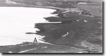 Bunyip River mouth (A) and adjacent coast, Site 89. |
Access: | No public road access is possible. The nearest road is the south Gippsland Highway. | |
Ownership: | Crown Land and private land. | |
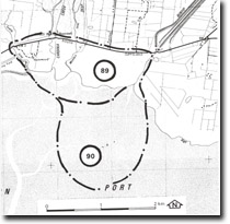
Geology/Geomorphology: | The coastal area consists of intertidal flats, sand beaches, chenier ridges, and mangrove and salt marsh zones which are crossed by a network of active and abandoned tidal creeks. Mangroves extend along the tidal creeks to the north of the South Gippsland Highway. Near the Moodys Inlet bridge is a small area of Spartina, an introduced grass that grows in intertidal areas. The grass was introduced in 1964 by the Soil Conservation Authority and has persisted despite attempts to remove it (Ken, Boston, pers. comm.). The intertidal flats are predominantly sandy and there are sand beaches and sand chenier ridges in gaps in the mangrove zone. Much of this sand has been delivered as a result of the enlarging and deepening of the Bunyip River channel during the drainage operations of the Koo-Wee-Rup Swamp. This had allowed an increased flow of fresh water and sandy sediment into Westernport Bay and resulted in the growth of substantial inter-tidal delta (Site 90). There has been substantial die-back of mangroves adjacent to the river mouth, accompanied by shoreline erosion and emplacement of sandy chenier ridges. The boundary between marine and non-marine deposits at the rear of the salt marsh is marked by a low but distinct abandoned cliff. This marks the maximum extent of the Holocene marine transgression in the northern part of the Westernport Bay. | |
Significance: | National. The area displays the impact of the drainage of the Koo-Wee-Rup Swamp upon the adjacent coast. By comparison with records and maps dating back to 1842 the site provides a major reference point for measuring the rates and nature of coastal change. Comparison may be made with areas such as Watsons Inlet (Site 80) which have been less effected by drainage schemes. The distinctive low cliff between the salt marsh and the fluvial and swamp deposits (as marked by the abandoned cliff) is an important feature in determining the Holocene sea level history of the Westernport region. | |
Management: | Class 1. No engineering works should be undertaken on the coast of the site. The boundary of the salt marsh (the low cliff) should be left undisturbed and no levee banks or drainage ditches should be constructed between this line and low water mark. As the spread of Spatina has serious geomorphological consequences (Boston 1981), surveys should be undertaken annually to determine if this grass is spreading into adjacent inlets, and consideration given to containing this spread. | |
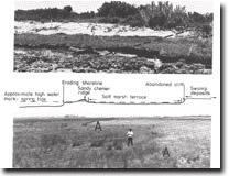 Eroding coast and chenier formation, Bunyip River mouth, Site 89. Diagram shows section on broken line. |

© State of Victoria (Agriculture Victoria) 1996 - .

This work, Victorian Resources Online, is licensed under a Creative Commons Attribution 4.0 licence. You are free to re-use the work under that licence, on the condition that you credit the State of Victoria (Agriculture Victoria) as author, indicate if changes were made and comply with the other licence terms.
The licence does not apply to ‘branding’ or some ‘images or photographs’ that may be owned by third parties. We ask you to seek prior approval to use images using the VRO feedback form. Access to higher quality images can also be provided on request.
This page was last updated on .