
90. Bunyip River Delta
|
This information has been developed from one or more of these publications:
|
| Location: | Tooradin – 643680. Six kilometres east of Tooradin. | 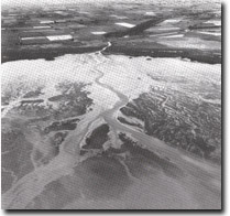 Sandy fan delta of the Bunyip River, Site 90 |
Access: | From South Gippsland Highway, or small boat in Bunyip River. | |
Ownership: | Crown Land. | |
Geology/Geomorphology: | Since the drainage and diversion of the lower reaches of the Bunyip river into the Main Catch Drain, commencing in 1889, an extensive subaqueous and intertidal delta has developed from the mouth of Reeces Inlet. The delta is a result of the increased and concentrated outflow from the drain, and the increased sediment load derived from scour of the floor of the drain and the river channels upstream. This accumulation began almost as soon as the Main Drain was completed (Key, 1967). The delta is in the form of a fan-like sand sheet crossed by astonishing and braided channels. The predominant sediment is a poorly sorted coarse sand that overlies the finer-grained tidal flat sediments. Stratified layers of sand, gravel, and mud may be seen in tidal channels incised into the deltaic deposits. | |
Significance: | Regional. The delta is an example of the substantial changes to landform that resulted from draining the Koo-Wee-Rup Swamp. The impact of reclamation schemes on adjacent coasts is demonstrated by the die-back of mangroves in the zone adjacent to the Bunyip River mouth. | |
Management: | Class 2. The delta is essentially an artificial landform but the rates and methods of its growth are of scientific interest. Any change in the utilisation of the intertidal zone that would alter the nature of the delta needs to be considered in terms of its impact on the total coastal and nearshore ecosystem and not just the features of the deltaic zone. For example, coastal reclamation schemes, dredging, and port and harbour facility construction would need to be considered in this way. | |
References: | Key, L.M. (1967). Historical geography of the Kooweerup District. M.A. thesis (unpub.) Dept. of Geog. Univ. of Melb. Bird, E.C.F. and Barson, M.M. (1975). Shoreline changes in Westernport Bay. Proc. Roy. Soc. Vict. 87 (1) 15-28. Masrden, M.A.H. and Mallett, C.W. (1975). Quaternary evolution, morphology and sediment distribution, Westernport Bay, Victoria. Proc. Roy. Soc. Vict. Vol. 87 (1) 107-137. | |
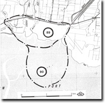 Site 90, Bunyip River Delta |

© State of Victoria (Agriculture Victoria) 1996 - .

This work, Victorian Resources Online, is licensed under a Creative Commons Attribution 4.0 licence. You are free to re-use the work under that licence, on the condition that you credit the State of Victoria (Agriculture Victoria) as author, indicate if changes were made and comply with the other licence terms.
The licence does not apply to ‘branding’ or some ‘images or photographs’ that may be owned by third parties. We ask you to seek prior approval to use images using the VRO feedback form. Access to higher quality images can also be provided on request.
This page was last updated on .