
80. Watson Inlet and Quail Island
|
This information has been developed from one or more of these publications:
|
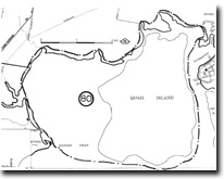
| Location: | Devon Meadows – 470661 to 514662. Coastal area west of Rutherford Inlet. Quail Island is linked to the mainland at low tide by a zone of mangrove and salt marsh. | 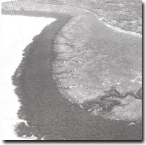 Tidal creeks crossing the broad salt marsh and mangrove zone on the western shore of Quail Island, Site 80. |
Access: | No public road access is possible. Inspection of the area may only be carried out at low tide from small boats. | |
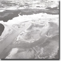
Geology/Geomorphology: | Watson inlet is funnel-shaped with a main central tidal drainage system and many small tributary tidal creeks. The entire inlet is mangrove fringed and landward of this is a wide salt marsh zone. There is a tidal watershed at the head of the tidal creeks linking Watson Inlet and Rutherford Inlet north of Quail Island. Quail Island preserves an undisturbed topography developed on Cranbourne Sands, with important examples of the associated inter-dune swamps and lakes. There are relict sandy spits and beaches behind a broad mangrove fringe. On the eastern shore of the island, opposite the Warneet jetty, erosion of the edge of the salt marsh exposes a former gravel beach resting on the eroded surface of the Warneet Beds. | |
Significance: | State. This is the least disturbed mangrove and salt marsh area on the mainland shore of Westernport Bay. It is a major site in Victoria to study the nature of sedimentation in a mangrove environment and the role of the mangroves in prompting sediment accumulation. The area of Cranbourne Sands topography is one of the largest of these areas left undisturbed in the Westernport region. The relict sandy spits are of similar significance to that described at Bungower Point (Site 79). | |
Management: | Class 1. High priority must be given to preserving the entire tidal drainage system of Watson Inlet including the salt marsh, mangrove, inter-tidal and sub-tidal areas. Further dredging and deepening of tidal creek systems should be prohibited and control must be exercised on extending land drainage and waste water outlets into and across the mangrove and salt marsh zone. The development of any harbour or launching facilities inside the area of the site should be prohibited. | |
 Tidal creeks crossing the broad salt marsh and mangrove zone on the western shore of Quail Island, Site 80 |

© State of Victoria (Agriculture Victoria) 1996 - .

This work, Victorian Resources Online, is licensed under a Creative Commons Attribution 4.0 licence. You are free to re-use the work under that licence, on the condition that you credit the State of Victoria (Agriculture Victoria) as author, indicate if changes were made and comply with the other licence terms.
The licence does not apply to ‘branding’ or some ‘images or photographs’ that may be owned by third parties. We ask you to seek prior approval to use images using the VRO feedback form. Access to higher quality images can also be provided on request.
This page was last updated on .