
Detailed Soil Surveys
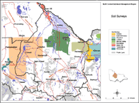
More detailed soil and land information for selected areas is also available here. Initially, more detailed maps and associated information has been provided from the Rochester and Eastern Wimmera soil and land surveys. The map on the right shows these areas and can be clicked on to go to relevant information. |
Over 25 soil surveys have been carried out which cover parts of the North Central region. To find details about these surveys and their availability from DEDJTR libraries access the Soil and Land Survey Directory.
© State of Victoria (Agriculture Victoria) 1996 - .

This work, Victorian Resources Online, is licensed under a Creative Commons Attribution 4.0 licence. You are free to re-use the work under that licence, on the condition that you credit the State of Victoria (Agriculture Victoria) as author, indicate if changes were made and comply with the other licence terms.
The licence does not apply to ‘branding’ or some ‘images or photographs’ that may be owned by third parties. We ask you to seek prior approval to use images using the VRO feedback form. Access to higher quality images can also be provided on request.
This page was last updated on .