
EGC206
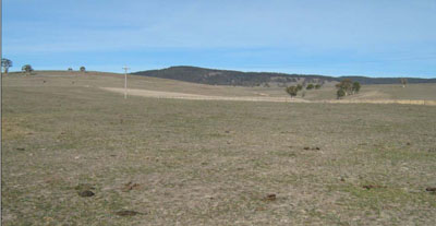
Location: Omeo South
Australian Soil Classification: Eutrophic, Mottled-Subnatric, Brown SODOSOL
Map Unit: Undulating low hills
Previous Site Name: EG206
General Landscape Description: Omeo (Component 1)
Site description: Convex lower slope, 2 % slope to North
Land Use: Grazing on annual pasture
Native Vegetation: Montane grassy woodland
Geology: Palaeozoic granite
Soil Profile Morphology:
| Surface soil | 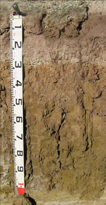 | ||
| A1 | 0 – 15 cm | Brown (7.5YR4/2); sandy loam; weak medium (10 – 20 mm) polyhedral structure; firm consistence dry; clear change to: | |
| A2 | 15 – 32 cm | Pale brown (10YR6/3) conspicuously bleached (10YR8/2d); sandy loam; apedal weak consistence dry; few (2 – 10 %) medium (2 – 6 mm) ferruginous concretions; sharp change to: | |
| Subsoil | |||
| B21 | 32 – 70 cm | Dark yellowish brown (10YR4/6) diffusely mottled with greyish brown (10YR5/2); medium clay; weak to moderate coarse (20 – 50 mm) prismatic structure; strong consistence dry; diffuse change to: | |
| B22 | 70 – 110+ cm | Brown (10YR4/3); medium clay; moderate coarse (20 – 50 mm) lenticular structure; strong consistence dry |
Key Profile Features:
- Strong texture contrast between the surface (A) horizon and the subsoil (B) horizon.
- Conspicuously bleached subsurface (A2) horizon.
- Vertic properties in the deep subsoil (i.e. slickensides).
Soil Profile Characteristics:
- | pH | Salinity | ||
Surface soil (A1 horizon) | Strongly Acid | Very Low | Non-sodic | Slight |
Subsoil (B21 horizon) | Slightly Acid | Very Low | Non-sodic | None |
Deeper subsoil (B22 horizon) | Slightly Alkaline | Low | Sodic | None |
Chemical and Physical Analysis:
Horizon | Horizon Depth (cm) | pH (water) | pH (CaCl2) | EC dS/m | Organic Carbon % | Total Nitrogen % | Exchangeable Aluminium ppm | Exchangeable Acididty meq/100g | Exchangeable Cations | Coarse Sand (0.2-2.0 mm) % | Fine Sand (0.02-0.2 mm) % | Silt (0.002-0.02 mm) % | Clay (<0.002 mm) % | Field Capacity % w/w | Wilting Point % w/w | |||
Ca | Mg | K | Na | |||||||||||||||
meq/100g | ||||||||||||||||||
A1 | 0-15 | 5.3 | 4.6 | 0.07 | 2.1 | 0.15 | <10 | 5.6 | 2.7 | 0.56 | 0.16 | 0.12 | 22 | 36 | 28 | 7 | 23.3 | 5.2 |
A2 | 15-32 | 5.4 | 4.7 | <0.05 | 0.59 | <0.05 | <10 | 2.1 | 1.4 | 0.36 | <0.05 | 0.11 | 22 | 37 | 28 | 8 | 17.7 | 3.5 |
B21 | 32-70 | 6.5 | 5.7 | 0.14 | 0.55 | 5.8 | 6.3 | 7.4 | 0.26 | 1.3 | 15 | 15 | 12 | 54 | 31.0 | 18.8 | ||
B22 | 70-110 | 7.3 | 6.6 | 0.31 | 0.38 | 6 | 12 | 20 | 60 | 38.8 | 22.2 | |||||||
Management Considerations
Whole profile
- The soil shows marked texture contrast between the surface soil and the subsoil.
- Plant available water content is quite low based on a root depth of 45 cm. The dense and coarsely structured subsoil is likely to restrict root growth and confine most of the roots to the surface soil.
- The low wilting points (5.2 and 3.5 %) of the surface soils indicates the plants are able to utilize very light rains when the soil is dry. However, due to the low water storage capacity, plants will soon suffer moisture stress unless further rains occur.
- The surface soils are strongly acid. However the level of exchangeable aluminium is reasonably low 16 mg/kg) and is unlikely to affect the growth of aluminium sensitive species, except the most sensitive. Lime can be used to increase soil pH but a pH/aluminium test is best performed by taking samples across the paddock and bulked together. The use of test strips to observe lime response could be used as an aid in evaluating its cost/benefit. For this soil a response to lime (about 1-2 tonnes/ha) would be expected.
- The organic matter content of the soil is moderate. Such levels result in a moderate structural condition and moderate structural stability. Careful pasture management is needed to maintain organic matter levels.
- Potassium is too low for pastures and a response to potassium fertilisers would be anticipated.
- Salinity is not a problem in the surface soil.
- The nutrient holding capacity of the surface (A1 and A2) horizons is very low (based on the sum of the exchangeable calcium, magnesium, potassium and sodium cations).
- The bleached subsurface layer lacks structure, sets hard when dry, impedes plant growth and slakes when wet.
- The coarsely structured and high clay subsoil is sodic with a low calcium to magnesium ratio of 0.8. Water and root movement in the subsoil will be restricted by these conditions.
- Root and water movement is likely to be restricted in the dense and coarsely structured subsoil. Mottled colours indicate the subsoil is imperfectly drained in wet periods.
- This soil is highly prone to water erosion.
- The roots tend to follow cracks between the soil aggregates and can only extract part of the soil water.
- Salinity in the deep subsoil (70 cm) is higher than normal and may restrict the growth of deep rooted species.
Profile Described By: Heather Adams, Julieanne Sargant and Ian Sargeant, June 2009.
© State of Victoria (Agriculture Victoria) 1996 - .

This work, Victorian Resources Online, is licensed under a Creative Commons Attribution 4.0 licence. You are free to re-use the work under that licence, on the condition that you credit the State of Victoria (Agriculture Victoria) as author, indicate if changes were made and comply with the other licence terms.
The licence does not apply to ‘branding’ or some ‘images or photographs’ that may be owned by third parties. We ask you to seek prior approval to use images using the VRO feedback form. Access to higher quality images can also be provided on request.
This page was last updated on .