
Land Resource Assessment in the Western part of the Shire of Towong
Land resource assessment has been undertaken in the Lake Hume catchment over an area formerly in the Shire of Tallangatta and is now incorporated within the Shire of Towong. The aim was to provide an inventory of land types and an understanding of their inherent land processes as a basis for sound land use and land management decisions. The study 'Land Resource Assessment in the Western Part of the Shire of Towong - Covering the Former Shire of Tallangatta' was carried out by the former Centre for Land Protection Research in July 1999, by R Hook and D Rees.
To view the information PDF requires the use of a PDF reader. This can be installed for free from the Adobe website (external link).
 | Front Page and Table of Contents (PDF 23KB) Acknowledgements (PDF 139KB) | |
| Abstract (PDF 15KB) | ||
1 | Introduction (PDF 226KB) | |
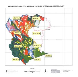
2 | Physical Characteristics of the Land (PDF 1.5MB) | |
3 | Land Classification (PDF 48KB) | |
4 | Land Type Descriptions (PDF 1.5MB) | |
| Appendix 1 - Sources of Information and Notes on Methodology for Data in Land Type Tables. (PDF 31KB) | ||
| Appendix 2 - Notes on Assessment of Susceptibility of Land Types to Deterioration. (PDF 54KB) | ||
| Appendix 3 - Laboratory Data for Selected Soil Profiles. (PDF 887KB) |
 Legend (PDF 329KB) | 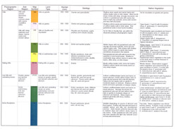 Legend (PDF 296KB) |
© State of Victoria (Agriculture Victoria) 1996 - 2025.

This work, Victorian Resources Online, is licensed under a Creative Commons Attribution 4.0 licence. You are free to re-use the work under that licence, on the condition that you credit the State of Victoria (Agriculture Victoria) as author, indicate if changes were made and comply with the other licence terms.
The licence does not apply to ‘branding’ or some ‘images or photographs’ that may be owned by third parties. We ask you to seek prior approval to use images using the VRO feedback form. Access to higher quality images can also be provided on request.
This page was last updated on 25/01/2019.