
Bonegilla Railway Siding
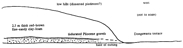
Figure 6: Stratigraphy at the Bonegilla Railway Siding.
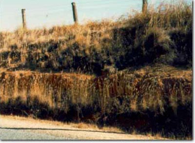
On the broad low divide between the Mitta Mitta and Kiewa valleys at Bonegilla, the railway cutting and adjacent road cutting expose a hardpan which has formed within the surface of Pliocene gravels (King 1979; O’Shea 1979). The railway cutting (Site No. 6) is in the embankment of the old Bonegilla railway siding on the eastern side of the Kiewa Valley (Figure 6). The cutting exposes up to 2.5 m of fine sandy clay loam to light clay, abruptly overlying Pliocene fluvial gravels (O’Shea 1979). The upper 0.3-0.5 m of the gravels is cemented. A similarly cemented gravelly hardpan is exposed in the cutting on the Murray Valley Highway just north of this at Site No. 7 (Photo 10), as well as in the rail cutting on either side of the Highway bridge about 2 km east of Bonegilla Siding at Site No. 8. It is apparent that the hardpan in the upper layer of the Bonegilla gravels is extensive in this area. The overlying fine sandy clayey sediments seem unlikely to be derived either from the Pliocene gravels or the few outliers of granite which occur as low hills in the Bonegilla area. The Kiewa River lies immediately to the west and Rowe (1994) suggested that this blanket of fine material is wind transported sediment derived predominantly from Kiewa River alluvium.
© State of Victoria (Agriculture Victoria) 1996 - .

This work, Victorian Resources Online, is licensed under a Creative Commons Attribution 4.0 licence. You are free to re-use the work under that licence, on the condition that you credit the State of Victoria (Agriculture Victoria) as author, indicate if changes were made and comply with the other licence terms.
The licence does not apply to ‘branding’ or some ‘images or photographs’ that may be owned by third parties. We ask you to seek prior approval to use images using the VRO feedback form. Access to higher quality images can also be provided on request.
This page was last updated on .