
Land Degradation
Land Degradation near Dookie
The tunnel and gully erosion maps for the Goulburn Broken catchment management region are subsets from the original data presented in the articles on tunnel erosion and gully erosion in the Statewide VRO website, so that the accuracy of information has not been improved.
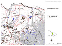 Goulburn Broken Tunnel Erosion |
Tunnelling was found throughout much of the region although some may have been destroyed (such as those discussed by Downes in 1949) whilst new tunnels may have formed elsewhere and are not marked. |
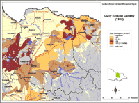 Goulburn Broken Gully Erosion |
|
Reference
Downes, R.G. (1949). ‘A Soil, Land-Use and Erosion Survey of Parts of the Counties of Moira and Delatite, Victoria’. CSIRO Bulletin No. 243.

© The State of Victoria, 1996 - .
This page was last updated on .