
Declared Water Supply Catchments
Back to: Declared Special Water Supply Catchments Areas in Victoria
Many catchments supplying water for domestic, irrigation or other purposes within Victoria are protected under the Catchment and Land Protection Act 1994. These catchments have significant values as a source of water supply, both for domestic and for stock and domestic use. This information assists planners and those managing land disturbance or development activities to readily determine the suitability of proposed activities within these catchment areas. Once a catchment is 'Declared', approvals for activities conducted under other statutes and statutory planning schemes must be referred to the responsible land management authority (water authority, CMA or DELWP).
| This map shows the location of Declared Special Water Supply Catchment Areas in the Goulburn Broken region. The table below provides links to legacy documents associated with these catchments. | 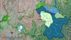 |
Declared Special Water Supply Catchments Areas throughout the Goulburn Broken region include:

© The State of Victoria, 1996 - .
This page was last updated on .