
EGS255
Location: Fernbank (Tom’s Creek flood plain)
Australian Soil Classification: Mesotrophic, Mottled-Subnatric,Brown SODOSOL
Map Unit: Fernbank
Previous Name: EG255
General Landscape Description: Meander plain
Site description: Level
Native Vegetation: Plains grassy woodland
Geology: Neogene alluvial sediments
Soil Profile Morphology:
Surface Soil
| A11 | 0-30 cm | Greyish brown (2.5Y5/2); loamy sand; massive; clear change to: | 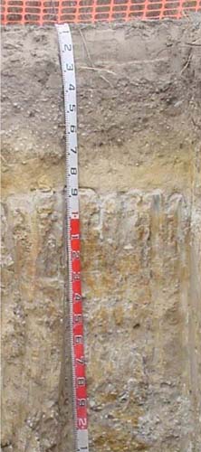 |
| A12 | 30-65 cm | Dark grey (10YR4/2); loamy coarse sand; massive, loose to very weak consistence moist; abundant (50-90%) rounded quartz pebbles (20-60 mm); clear change to: | |
| A21 | 65- 85/90 cm | Yellowish brown (10YR5/4); coarse sand; massive; sharp wavy change to: | |
| 2A22 | 85/90-100/110 cm | Light grey; sandy loam; massive; sharp tongued boundary to: | |
| Subsoil | |||
| 2B2 | 100 /110 – 180 cm | Greyish brown (2.5Y5/2) with common (10-20%) medium (5-15 mm) yellowish brown (10YR5/6) mottles; light medium clay; strong very coarse columnar structure, strongly parting to medium angular blocky; strong consistence dry; few (2-10%) large (20-60 mm) rounded quartz pebbles; diffuse change to: | |
| 2C | 180 – 270 cm | Brown (10YR5/3) with few (2-10%) faint coarse (15-30 mm) yellowish brown mottles; coarse sandy clay loam; massive; abundant (50-90%) large (20-60 mm) rounded quartz pebbles |
Key Profile Features:
- Strong texture contrast between the sandy top soil and the medium heavy clay subsoil.
- The surface 70 cm layer appears to have been deposited at a different period to the underlying layers.
Soil Profile Characteristics:
- | pH | Sodicity | |
Sub-surface (A11 horizon) | Strongly acidic | Non sodic | None |
(2A2 horizon) | Strongly acidic | Non sodic | None |
Subsoil 110-180 cm | Moderately acidic | Sodic | None |
Chemical and Physical Analysis:
Horizon | Horizon Depth (cm) | pH (water) | pH (CaCl2) | EC dS/m | Organic Carbon % | Total Nitrogen % | Exchangeable Aluminium ppm | Exchangeable Acididty meq/100g | Exchangeable Cations | Coarse Sand (0.2-2.0 mm) % | Fine Sand (0.02-0.2 mm) % | Silt (0.002-0.02 mm) % | Clay (<0.002 mm) % | Field Capacity % w/w | Wilting Point % w/w | |||
Ca | Mg | K | Na | |||||||||||||||
meq/100g | ||||||||||||||||||
A11 | 0-30 | 0.7 | <0.05 | 6.6 | 1.9 | |||||||||||||
A12 | 30-65 | 5.1 | 4.4 | <0.05 | 0.8 | <0.05 | 14 | 2.1 | 0.5 | 0.3 | <0.1 | <0.1 | 31 | 62 | 3 | 3 | 7 | 2.8 |
A2 | 65-90 | 5.2 | 4.4 | <0.05 | 0.3 | <0.05 | 36 | 3 | 0.2 | 0.4 | <0.1 | <0.1 | 62 | 27 | 3 | 4 | 5.6 | 1.4 |
2A21 | 90-100 | 5.4 | 4.7 | <0.05 | 7 | 1.1 | <0.1 | 0.1 | <0.1 | <0.1 | 55 | 39 | 3 | 2 | 9.5 | 4 | ||
2A22 | 100-110 | 5.9 | 4.6 | <0.05 | 6 | 1.5 | <0.1 | 0.8 | <0.1 | <0.1 | 44 | 36 | 10 | 10 | 9.5 | 4 | ||
2B2 | 110-180 | 5.7 | 4.3 | 0.08 | 110 | 9 | <0.1 | 5.0 | 0.1 | 1.1 | 26 | 22 | 4 | 46 | 30.2 | 18.4 | ||
2C | 180-270 | 5.8 | 4.5 | 0.08 | 15 | 3.3 | <0.01 | 2.7 | 0.1 | 0.8 | 55 | 23 | 4 | 17 | 13.5 | 7.1 | ||
Management Considerations
Whole profile
- Plant available water is considered to be very low (estimated at 44 mm) for this profile based on an effective rooting depth of 65 mm.
Surface (A) horizons
- The surface soil is strongly acid and it would be expected liming may improve plant growth.
- Potassium is extremely deficient and a strong response to potassium fertiliser would be expected, provided phosphate was also added.
- The surface horizons have an extremely low nutrient holding capacity. Organic matter is important for maintaining nutrient and water holding capacity, especially in sandy soils.
- The low wilting points of the surface soils indicates plants will be able to use very light rains when the soil is dry. Due to the low water storage capacity of the surface soils, plants will soon suffer moisture stress unless follow-up rains occur.
- The depth to the clay would have little influence on plant growth as it occurs too deep in the profile.
Profile Described By: Ian Sargeant, 2001.
© State of Victoria (Agriculture Victoria) 1996 - .

This work, Victorian Resources Online, is licensed under a Creative Commons Attribution 4.0 licence. You are free to re-use the work under that licence, on the condition that you credit the State of Victoria (Agriculture Victoria) as author, indicate if changes were made and comply with the other licence terms.
The licence does not apply to ‘branding’ or some ‘images or photographs’ that may be owned by third parties. We ask you to seek prior approval to use images using the VRO feedback form. Access to higher quality images can also be provided on request.
This page was last updated on .