
Morass (Symbol: Ms)
Geology
Recent alluvium.
Landform
Alluvial plain at high elevation, comprising flood plains, with minor terraces and stream channels. These deposits encompassed by this map unit are confined to the Benambra and upper Morass Creeks and their tributaries, mostly between 700 and 900 m. Slopes are generally less that 3% with an elevation range of less than 9 m.
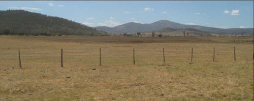
Photo taken from Beloka Road, looking east
| Original vegetation Montane riparian woodland with areas of subalpine wet heathland. Soils Component 1. This component includes most of the soils within this map unit. Most of the soils are on the present flood plain of these creeks. Limited observations showed the surface soils are shallow dark grey sandy loams to clay loams overlying very dark to dark grey strongly structured clays. Since European settlement, sediment resulting from erosion higher in the catchment has covered areas of this map unit. Component 2. This is a minor component of this map unit. The soils were not examined but an exposure on a farm dam wall showed a texture contrast soil with yellow brown clay subsoil. Component 3. The stream channels occupy only a minor area. Land use All of the area is cleared and used for grazing. | 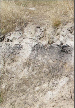 Photo: Erosion due to post European settlement higher in the catchment has resulted in recent sediment deposition (pale surface soil layer) over the original soil surface (dark to very dark strongly structured clays). |
© State of Victoria (Agriculture Victoria) 1996 - .

This work, Victorian Resources Online, is licensed under a Creative Commons Attribution 4.0 licence. You are free to re-use the work under that licence, on the condition that you credit the State of Victoria (Agriculture Victoria) as author, indicate if changes were made and comply with the other licence terms.
The licence does not apply to ‘branding’ or some ‘images or photographs’ that may be owned by third parties. We ask you to seek prior approval to use images using the VRO feedback form. Access to higher quality images can also be provided on request.
This page was last updated on .