
Recent marine (Symbol: rm)
Profile No. 771 (Nicholson, 1978)
Geology
Recent marine sediments with some aeolian sediments.
Landform
Low dunefields and tidal flats. This map unit encompasses salt marshes and low dunes and intervening flats mostly lower than 5 m above sea level.
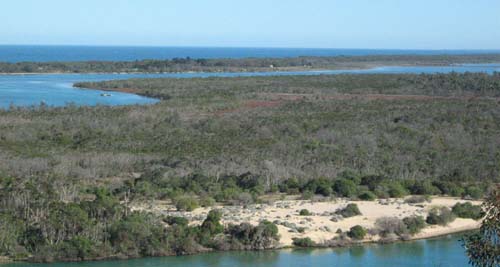
Salt marsh and low dunes generally less than 5 m above sea level
| Previous maps and Reports This map unit was included under the Clydebank, Wollaston and Morass Land Systems by Aldrick et al. (1992) and under Wulla Wullock with minor occurrences of Colquhoun by Nicholson (1978). Areas where dunes higher than 5 m above sea level occur are mapped as the Seacombe map unit. Soils The soils of the low dunes are likely to be alkaline sands, with low areas periodically affected by the tide likely to be alkaline and saline sands and clays. Shell fragments usually occur within the soil profile. Native Vegetation Complex of salt marsh and damp sands herb-rich woodland mostly under National and State Parks. | 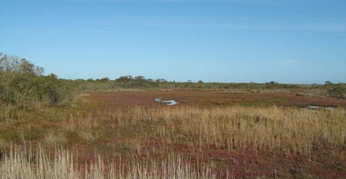 |
Profile No. 771 (Nicholson, 1978)
| Location: Not specified | |
| Australian Soil Classification: Arenic RUDOSOL | |
| General landscape description: Not specified | |
| Geology: Holocene marine sediments | |
| Site description: Not specified | |
| Land use: Not specified | |
| Native vegetation: Not specified | |
| Map unit: Recent marine |
Key profile features
- Sand textures throughout.
- The EC values indicate the soil is saline, alkaline and would only support salt marsh species.
- Shells are present throughout the profile.
| Horizon | Depth cm | Field texture | pH water | EC dS/m | Gravel % | Coarse sand % | Fine sand % | Silt % | Clay % | Field cap. % w/w | Wilt. point % w/w | PAW* water % w/w |
| Flood deposit | 0-4 | FSL | 8.3 | 6.3 | 5# | 22 | 44 | 1 | 5 | |||
| A1 | 4-6 | FS | 8.8 | 1.7 | 2# | 33 | 54 | 1 | 2 | |||
| C | 6-10 | FS | 9.0 | 0.87 | 3# | 24 | 67 | <1 | 1 | |||
| C | 10-20 | KS | 9.1 | 0.61 | 4# | |||||||
| C | 20-30 | KS | 9.1 | 0.62 | 3# | |||||||
| C | 50-60 | KS | 8.4 | 1.0 | 3# | 56 | 36 | <1 | 2 | |||
| D | 70-80 | KS | 8.1 | 2.1 | 43# | 58 | 19 | 2 | 9 |
# Shells
| Depth | Org C | Total N | Free Fe2O3 | Exch. Al | Exchangeable cations cmol(+)/kg | Ca:Mg | ESP | ||||||
| cm | % | % | % w/w | ppm | Ca | Mg | K | Na | Total | H | CEC | ||
| 0-4 | 2.0 | 0.18 | 1.0 | 7.8 | 7.8 | 1.0 | 4.0 | 20.6 | 0 | 20.6 | |||
| 4-6 | 0.52 | 0.05 | 0.1 | 4.8 | 2.7 | 0.4 | 1.3 | 9.2 | 0 | 9.2 | |||
| 6-10 | 0.24 | 0.03 | 0.1 | 3.1 | 1.2 | 0.2 | 0.4 | 4.9 | 0 | 4.9 | |||
| 10-20 | 0.08 | 0.01 | |||||||||||
| 20-30 | 0.05 | 0.01 | |||||||||||
| 50-60 | 0.3 | 3.2 | 0.7 | 0.2 | 0.3 | 4.4 | 0 | 4.4 | |||||
| 70-80 | 0.3 | 6.1 | 2.4 | 0.8 | 1.4 | 10.7 | 0 | 10.7 | 2.5 | 13 | |||
© State of Victoria (Agriculture Victoria) 1996 - .

This work, Victorian Resources Online, is licensed under a Creative Commons Attribution 4.0 licence. You are free to re-use the work under that licence, on the condition that you credit the State of Victoria (Agriculture Victoria) as author, indicate if changes were made and comply with the other licence terms.
The licence does not apply to ‘branding’ or some ‘images or photographs’ that may be owned by third parties. We ask you to seek prior approval to use images using the VRO feedback form. Access to higher quality images can also be provided on request.
This page was last updated on .