
Lindenow (Symbol: Li)
EG209 | Profile No. 24 | Profile No. 25
Geology
Recent alluvium.
Landform
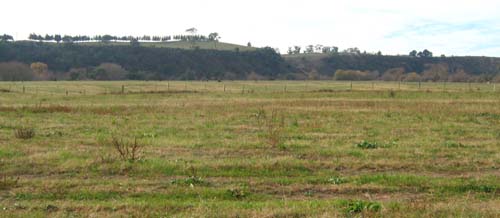
Level plain with slopes generally less than 1% with a relief <9m. Alluvial plains, comprising flood plains, and stream channels.
An interactive visualisation of the landscape in the Lindenow mapping unit is provided here. Zooming and panning functionality is provided as well as the ability to click on icons to provide further information about the landscape (e.g. soils, geology).
We've detected that the 'Flash Player' installed is either missing or not fully up-to-date and cannot play the content we've created.

For the best viewing experience please click on the icon above to install Adobe's Latest Flash Player.
Photo | Panoroma | Information | Soil pit | Video |
Use your keyboard and mouse to navigate the study area. To zoom in or out, left mouse click inside the panorama and use the mouse's 'scroll wheel' (if you have one) or press and hold 'Shift' or 'Ctrl'. To explore the landscape, click and hold the left mouse button on the landscape and move the mouse left, right, up or down or use 'cursor keys'.
The interactive landscapes is 4 MB in size, this might take some time to automatically download if you're using a slow internet connection. If you experience any problems you should update the 'Adobe Flash Player' used. This software can be downloaded for free from the Adobe website (external link).
This map unit is confined to the valleys of Mitchell River near Bairnsdale and the Tambo River south of Bruthen.
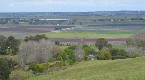
Mitchell River flats looking south towards Lindenow
Original vegetation
Dry valley forest, minor areas of floodplain reed-bed.
Soils
Component 1: Soils on flood plains
Most of the soils of this map unit occur on the flood plains. Generally they are moderately to slightly acidic dark greyish brown deep fine sandy to silty loams and silty clay loams, but layers of coarser material such and stones and gravel may occur deeper in the subsoil. Three soil profiles are described: Mitchell River flats, Tambo River flats south of Bruthen and near the Tambo River mouth.
Component 2: The stream channel
This is a very minor component of the map unit. Bed and bank erosion is common along the stream channels.
Land use
Mitchell River flats are used extensively for vegetable production with some grazing and the Tambo River flats for grazing.
Site EG209
| Location: Lindenow | Geo. Ref.: 545620E 5815860N |
| Australian Soil Classification: Melanic, Eutrophic, Brown KANDOSOL | Dark brown uniform textured soil |
| General landscape description: Level plain | |
| Geology: Recent alluvium | |
| Site description: <1% slope | |
| Land use: Vegetable production | |
| Native Vegetation: Dry valley forest, minor areas of floodplain reed-bed | |
| Map unit: Lindenow (Component 1) |
Soil profile morphology
Surface soil
| A11 | 0 – 15 cm | Dark brown (7.5YR3/2); silty loam; moderate fine granular structure; weak consistence dry; clear change to: | 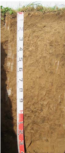 |
| Subsurface soil | |||
| A12 | 15 – 40 cm | Dark brown (7.5YR3/2); silty loam; weak coarse polyhedral structure; firm consistence dry; gradual change to: | |
| A13 | 40 – 70 cm | Brown (7.5YR4/2); silty loam; apedal; firm consistence dry; gradual change to: | |
| A14 | 70 – 110 cm | Brown (7.5YR4/2); silty loam; apedal; weak consistence dry; gradual change to: | |
| A15 | 110 – 140 cm | Brown (7.5YR4/2); silty loam. | |
- Uniform textures throughout.
| pH | Sodicity | Slaking | Dispersion Dry | Dispersion Remoulded | |
| Surface soil | Slightly acid | Non-sodic | Nil | Nil (2 hours), Nil (20 hours) | Nil (2 hours), Moderate (20 hours) |
| Subsurface (A12 horizon) | Moderately acidic | Non-sodic | Considerable | Nil (2 hours), Nil (20 hours) | Moderate (2 hours), Moderate (20 hours) |
| Deeper subsoil (70-110 cm) | Slightly acid | Non-sodic | Considerable | Nil (2 hours), Nil (20 hours) | Slight(2 hours), Slight (20 hours) |
| Horizon | Depth cm | Field texture | pH water | pH CaCl2 | EC dS/m | Coarse sand % | Fine sand % | Silt % | Clay % | Field cap. % w/w | Wilt. point % w/w | PAW* water % w/w |
| A11 | 0-15 | ZL | 5.9 | 5.1 | 0.06 | 2 | 44 | 19 | 26 | 28.9 | 9.6 | 19.3 |
| A12 | 15-40 | ZL | 5.6 | 4.7 | 0.05 | 0 | 46 | 31 | 16 | 28.2 | 8.2 | 20.0 |
| A13 | 40-70 | ZL | 6.4 | 5.4 | 0.05 | 0 | 48 | 30 | 15 | 20.1 | 7.1 | 13.0 |
| A14 | 70-110 | ZL | 6.5 | 5.5 | 0.05 | 0 | 46 | 28 | 19 | 26.3 | 5.7 | 20.6 |
| Depth | OrgC# | Total N | Free Fe2O3 | Exch. Al | Exchangeable cations cmol(+)/kg | Ca:Mg | ESP | ||||||
| cm | % | % | % w/w | ppm | Ca | Mg | K | Na | Total | H | CEC | ||
| 0-15 | 3.1 | 0.17 | <10 | 8.2 | 2.3 | 0.14 | 0.23 | 11 | 8.5 | 19.5 | 3.5 | 1 | |
| 15-40 | 2.2 | 0.10 | <10 | 7 | 2.3 | 0.095 | 0.15 | 9.5 | 8.9 | 18.7 | 3 | 1 | |
| 40-70 | 1.8 | <0.05 | <10 | 6.5 | 4.2 | 0.083 | 0.23 | 11 | 5.7 | 16.7 | 1.6 | 1 | |
| 70-110 | 1.6 | 0.05 | N/A | 5.8 | 5 | 0.091 | 0.32 | 11 | 4.4 | 15.4 | 1.2 | 2 | |
Management considerations
Whole profile
- The brown colours throughout and lack of texture contrast indicate the profile is well drained internally.
- Plant available water content capacity is considered to be low to moderate, (estimated at 62 mm) based on the laboratory data and an effective rooting depth of 70 cm.
- The soil has a normal organic matter content conferring average structural stability,
- The nutrient holding capacity of the soil is moderate (based on the sum of exchangeable cations),
- The potassium levels are low and the soil is expected to show a strong response to potassium fertilisers.
- The soil has no impeding layers to restrict root development.
Profile No. 24 (Aldrick et al, 1992)
| Location: Bruthen | Geo. Ref.: 0572400E 5824200N |
| Australian Soil Classification: Melanic, Eutrophic, Brown DERMOSOL | Dark brown uniform textured soil |
| General landscape description: Flood plain (hummocky) | |
| Geology: Recent alluvium | |
| Site description: 1% slope | |
| Land use: Grazing on annual pasture | |
| Native Vegetation: Dry valley forest, minor areas of floodplain reed-bed | |
| Map unit: Lindenow (Component 1) |
No photo available
Soil profile morphology
Surface soil
| A11 | 0 – 7 cm | Very dark greyish brown (10YR3/2); silty loam; moderate crumb structure; friable consistence moist; clear wavy change to: |
A12 | 7 – 17 cm | Very dark greyish brown (10YR3/2) abundant distinct brown mottles; silty loam; moderate fine (<5 mm) subangular blocky structure; friable consistence moist; diffuse wavy change to: |
AC | 17 – 27 cm | Very dark greyish brown (10YR3/2), abundant distinct brown (<5 mm) mottles; silty loam (with thin fine sand lenses); moderate fine (<5 mm) subangular blocky structure; friable consistence moist; abrupt smooth change to: |
11A1 | 27 – 52 cm | Very dark greyish brown (10YR3/2), abundant distinct brown (5 -15 mm) mottles; silty clay loam (with thin fine sand lenses); moderate coarse angular blocky structure; firm consistence moist; abrupt change to: |
11C | 52 – 90+ cm | Yellowish brown (10YR5/6), abundant distinct grey (5 -15 mm) mottles; silty loam; massive |
Key profile features
- Little change in clay content down the profile.
| Horizon | Depth cm | Field texture | pH water | EC dS/m | Gravel % | Coarse sand % | Fine sand % | Silt % | Clay % | Field cap. % w/w | Wilt. point % w/w | PAW* water % w/w |
| A11 | 0-7 | ZL | 6.2 | 0.21 | 0 | 2 | 43 | 18 | 17 | |||
| A12 | 10-17 | ZL | 6.3 | 0.14 | 0 | 1 | 54 | 18 | 15 | |||
| 11A1 | 30-52 | ZCL | 6.1 | 0.31 | 0 | <1 | 37 | 34 | 19 | |||
| 11C | 52-60 | ZL | 6.3 | 0.23 | 0 | <1 | 55 | 26 | 15 |
| Depth | OrgC# | Total N | Exch. Al | Exchangeable cations cmol(+)/kg | Ca:Mg | ESP | ||||||
| cm | % | % | ppm | Ca | Mg | K | Na | Total | H | CEC | ||
| 0-7 | 4.0 | 0.43 | 8.7 | 6.0 | 0.4 | 0.5 | 15.6 | 11.3 | 26.9 | 1.5 | 2 | |
| 10-17 | 2.3 | 0.20 | 8.0 | 4.3 | 0.1 | 0.5 | 12.9 | 8.0 | 20.9 | 1.9 | 2 | |
| 30-52 | 1.4 | 0.15 | 8.2 | 5.1 | 0.09 | 1.0 | 14.4 | 10.1 | 24.5 | 1.6 | 4 | |
| 52-60 | 1.5 | 0.11 | 7.0 | 4.1 | 0.04 | 0.8 | 11.9 | 9.3 | 21.2 | 1.7 | 4 | |
Profile No. 25 (Aldrick et al, 1992)
| Location: Tambo Mouth | Geo. Ref.: 0570700E 5810300N |
| Australian Soil Classification: Melanic-Sodic, Eutrophic, Brown DERMOSOL | Dark brown uniform textured soil |
| General landscape description: Delta | |
| Geology: Recent alluvium | |
| Site description: 1% slope on river delta | |
| Land use: Grazing on annual pasture | |
| Native Vegetation: Dry valley forest, minor areas of floodplain reed-bed | |
| Map unit: Lindenow (Component1) |
No photo available
Soil profile morphology
Surface soil
| A11 | 0 – 20 cm | Very dark brown (10YR2/2); silty loam; moderate crumb structure; friable consistence when moist; gradual wavy change to: |
A12 | 20 – 35cm | Black (10YR2/1); silty clay loam; moderate crumb structure; friable consistence moist; clear smooth change to: |
C1 | 35 – 46 cm | Dark brown (10YR4/3), abundant distinct grey (5-15 mm) mottles; silty clay loam; massive; friable consistence moist; clear smooth change to: |
C2 | 46 – 68 cm | Dark brown (10YR4/3), abundant distinct grey (5-15 mm) mottles) mottles; loamy sand; massive, firm consistence moist; clear change to; |
C3 | 68 – 90 cm | Dark yellowish brown (10YR4/6), abundant prominent grey (5 -15 mm) mottles; silty clay loam; massive; very firm consistence moist |
Key profile features
- Apart from a sand layer at 46 to 68 cm, there was little change in clay content down the profile.
| Horizon | Depth cm | Field texture | pH water | EC dS/m | Gravel % | Coarse sand % | Fine sand % | Silt % | Clay % | Field cap. % w/w | Wilt. point % w/w | PAW* water % w/w |
| A11 | 0-10 | ZL | 5.4 | 0.06 | 0 | 2 | 34 | 22 | 19 | |||
| A11 | 10-20 | ZCL | 5.6 | 0.02 | 0 | 2 | 41 | 24 | 19 | |||
| A12 | 30-35 | ZCL | 6.2 | 0.02 | 0 | 2 | 51 | 23 | 16 | |||
| C1 | 35-46 | ZCL | 6.5 | 0.02 | 0 | 3 | 54 | 23 | 14 | |||
| C3 | 68-90 | ZCL | 6.9 | 0.12 | 0 | 2 | 53 | 20 | 18 |
| Depth | OrgC# | Total N | Exch. Al | Exchangeable cations cmol(+)/kg | Ca:Mg | ESP | ||||||
| cm | % | % | ppm | Ca | Mg | K | Na | Total | H | CEC | ||
| 0-10 | 3.9 | 0.53 | 2.7 | 3.1 | 0.9 | 0.7 | 7.4 | 29.3 | 36.7 | 0.8 | 2 | |
| 10-20 | 4.0 | 0.33 | 1.8 | 2.1 | 0.5 | 0.6 | 5.0 | 27.7 | 32.7 | 0.9 | 2 | |
| 30-35 | 1.6 | 0.14 | 2.2 | 3.5 | 0.3 | 0.9 | 6.9 | 13.6 | 20.5 | 0.6 | 4 | |
| 35-46 | 1.1 | 0.08 | 2.7 | 4.7 | 0.2 | 1.1 | 8.7 | 7.6 | 16.3 | 06 | 7 | |
| 68-90 | 2.4 | 5.4 | 0.5 | 3.6 | 11.9 | 4.1 | 16.0 | 0.4 | 22 | |||
© State of Victoria (Agriculture Victoria) 1996 - .

This work, Victorian Resources Online, is licensed under a Creative Commons Attribution 4.0 licence. You are free to re-use the work under that licence, on the condition that you credit the State of Victoria (Agriculture Victoria) as author, indicate if changes were made and comply with the other licence terms.
The licence does not apply to ‘branding’ or some ‘images or photographs’ that may be owned by third parties. We ask you to seek prior approval to use images using the VRO feedback form. Access to higher quality images can also be provided on request.
This page was last updated on .