
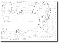
GL41 (8321) Tucker Point and Tucker Lagoon
|
This information has been developed from the publications:
|
| Location: | 265805 to 285785. | 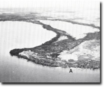 Lake Wellington. Eroding shoreline (A), on the western shore of Tucker Point. |
Abstract: | Eroding shoreline; Melaleuca fringed shoreline; lake and swamp. | |
Access: | Boat in Lake Wellington. | |
Ownership: | Private land. | |
Geomorphology: | The southern shoreline of Lake Wellington east from the Latrobe River contains the largest area of freshwater swampland that remains in and adjacent to the Gippsland Lakes. The swamps are either dense thickets of Melaleuca ericfolia or broad tracts of Phragmites australis grassland. The Phragmites which was previously extensive along the lake shoreline, is now restricted to areas inland, and the lake shore vegetation on the south-east of Lake Wellington is typically eroding stands of Melaleuca. Erosion is most pronounced on shoreline sectors that face westerly into the strongest wave action, e.g. south-west of Tucker Point, and is less severe on more sheltered areas which still retain a sparse Phragmites fringe. | |
The shoreline erosion is probably due to die-back of Phragmites initiated during drought seasons when salinities in Lake Wellington become much higher than average and approach the level of tolerance for regeneration of Phragmites. Extensive reduction of Phragmites reed swamp on the southern shore of Lake Wellington has been noted since 1957-58. | ||
Significance: | Regional. This is the largest surviving freshwater reed swamp and Melaleuca area in the Gippsland Lakes region. | |
Management: | As in other parts of the Gippsland Lakes, die-back of vegetation and subsequent shoreline erosion has been attributed to salinity increase following opening of the artificial entrance. As very little action can be taken to reduce this effect, other activities that disturb the swamp vegetation, e.g. grazing, clearing, should be avoided. | |
 Sites GL-40 41 42 |
© State of Victoria (Agriculture Victoria) 1996 - .

This work, Victorian Resources Online, is licensed under a Creative Commons Attribution 4.0 licence. You are free to re-use the work under that licence, on the condition that you credit the State of Victoria (Agriculture Victoria) as author, indicate if changes were made and comply with the other licence terms.
The licence does not apply to ‘branding’ or some ‘images or photographs’ that may be owned by third parties. We ask you to seek prior approval to use images using the VRO feedback form. Access to higher quality images can also be provided on request.
This page was last updated on .