
GL40 (8321) McLennans Isthmus and McLennans Strait
|
This information has been developed from the publications:
|
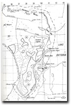
| Location: | Eastings 350 to 415, Northings 815 to 940 (8321). | 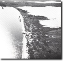 McLennans Isthmus. Blowouts (arrowed). Eroding sector (A-A') Accreting sector (B-B') |
Abstract: | Segmentation of Lakes Wellington/Victoria by compound recurbed spit. | |
Access: | Bengworden Road to Hollands Landing on northern side of McLennans Strait, and eastern shore of Lake Wellington; Loch Sport Road to Seacombe on southern side. | |
Ownership: | Mainly private land. | |
Geomorphology: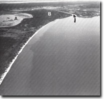 McLennans Isthmus and McLennans Strait (arrowed). Salt Swamp (A) Recurving spit complex (B) | Lakes Victoria and Wellington are separated by a long, broad tract of sandy and swampy terrain that represents an advanced stage of segmentation of a formerly larger lagoon. The lakes are now connected only by a narrow residual channel (McLennans Strait) and as a result of the separation, the lakes exhibit marked contrast in hydrological and ecological conditions. | |
McLennans Isthmus is a long, sandy promontory that extends south-west from Roseneath Point as a narrow, gently curving beach, backed by low beach ridges crossed by numerous small blowouts and parabolic dunes. Erosion and retreat of this beach is evident along the northern sector where stumps of Melaleuca, banksias and eucalypts are stranded in Lake Wellington 40 to 50 metres from the shoreline. The spit has grown south-eastward from a remnant of the prior barrier that forms the low plain south-east of Meerlieu and has thus enclosed low lying areas with the resultant development of lakes and swamps. The marginal bluff lies well inland here, diverging adjacent to Toms Creek as valley side bluffs. | ||
The southern section of McLennans Isthmus is a compound recurving spit with several parallel ridges that terminate in the swampland north of McLennans Strait. The spit has grown under the influence of waves generated b westerly winds which have moved sand across Lake Wellington from the mouths of the Latrobe and Avon rivers and from eroded shorelines on the north. The broadening of the spit to the south-east indicates a net sediment drift to that direction, the recurves being shaped by waves from the south-west before the development of the extensive swampland in Lake Wellington west of Seacombe. The southern section of the isthmus is still receiving sediment from Lake Wellington and is an accreting shoreline in contrast to the eroding sector to the north. | ||
McLennans Strait is a deep narrow channel that connects Lakes Wellington and Victoria and maintains sufficient current flow to prevent the extension of the sandspit and incursion by reed swamp that would result in complete closure of Lake Wellington. The current pattern in the Strait is complex, and reflects tidal movement through Lake Victoria as well as wind generated currents in Lake Wellington. Outflow into Lake Victoria is indicated by the reed-fringed delta that forms Medusa Point and Griffin Point. | ||
Significance: | State. This is a large scale example of the processes of lake segmentation by growth of spits which eventually become oriented at right angles to the direction of approach of dominant waves. The area indicated contains an array of features (e.g. beaches, lakes, swamps, channels) which indicate the different stages in the development of the segmentation process. The contrasting shorelines of Lake Wellington and Victoria on either side of McLennan Isthmus indicate both the different wave regime operative and the variation in salinity between the two lakes. | |
Management: | Blowout extension from the northern section of the spit may increase due to grazing pressure, but some dune movement is to be expected due to the aspect of the shoreline. Serious disturbance to the vegetation of the recurved spit area near McLennans Strait could initiate blowout activity here. The extensive wetland show evidence of recent salt accumulation and resultant vegetation die-back and require detailed management studies to determine the local impact of specific development proposals. | |
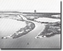 McLennans Strait delta. Lake Victoria (A) Lake Wellington (B) |
© State of Victoria (Agriculture Victoria) 1996 - .

This work, Victorian Resources Online, is licensed under a Creative Commons Attribution 4.0 licence. You are free to re-use the work under that licence, on the condition that you credit the State of Victoria (Agriculture Victoria) as author, indicate if changes were made and comply with the other licence terms.
The licence does not apply to ‘branding’ or some ‘images or photographs’ that may be owned by third parties. We ask you to seek prior approval to use images using the VRO feedback form. Access to higher quality images can also be provided on request.
This page was last updated on .