
8822-11 Bastion Point to Little Rame Head
|
This information has been developed from the publications:
|
Location: | 441378 to 355255. Coastal cliffs and rock platforms extending from Bastion Point near Mallacoota Inlet for 18 kilometre south-west to Little Rame Head. | 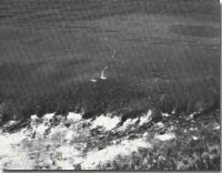 Ordovician Mallacoota Beds at Little Rame Head. |
Abstract: | Lithology, structure, weathering and erosion features of Ordovician sedimentary rocks. | |
Access: | Road to Mallacoota airport and 4-wheel drive or walking tracks along coast to rear of Little Rame Head. | |
Ownership: | Crown Land (mainly Croajingolong National Park). Area adjacent to Mallacoota airport is Commonwealth Land. | |
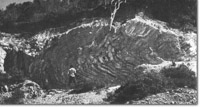
Geology: 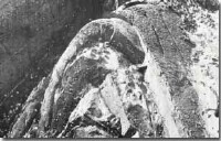 Plunging antiform in Ordovician sediments - Shipwreck Creek. | The area contains a major exposure of the Ordovician Mallacoota Beds. These are predominantly dark grey sandstones (greywacke), quartzites, shales and slates, and in places include grey and nodular cherts. The trend of the strikes of the beds in north-north-east and is generally parallel to the coastline but varies locally as a result of folding and faulting. Of major interest is the array of depositional structure including graded bedding, ripple marks and flute casts and a variety of fold, fault and joint structure which is exposed in cliffs and shore platforms at Bastion Point, Fishermans Rocks and between Seal Creek and the western side of Little Rame Head. Large fold structures are particularly well exposed near Mallacoota airport and at Shipwreck Creek. The sedimentary rocks are intruded by numerous gabbroic and andesitic dykes and sills. Tension fractures are commonly filled with smaller quartz veins while silica and limonite deposition occupies joint planes. Detailed geological mapping of the area has been carried out by the Geology Department at the University of Melbourne. The Ordovician rocks are thinly covered by non-marine Tertiary sediments but the contact between the formations is generally obscured by slumping and thick coastal scrub growth on the upper sections of coastal cliffs and bluffs. | |
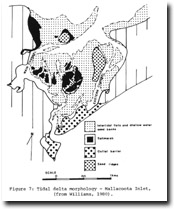
Geomorphology: | Erosion of the structures of the Ordovician rocks has produced a coastline of the intricate detail. The main coastal landform is a serrated shore platform with the quartzite beds projecting as ribs and ridges above the softer beds. The platform is intersected by gutters eroded along fault and joint planes, rock stacks are prominent near Shipwreck Creek. Differential weathering and filling of fracture planes by limonite has produced boxwork and honeycomb weathering features. An arch or sea cave between Mallacoota Airport Beach and Betka River is shown. Beaches are typically of gravel with the main sand beaches being at the mouth of the Betka River, Seal Creek and Shipwreck Creek. There are no major active dunes along this coastal sector although low stabilised parabolic dune ridges and irregular hummocks occur at Little Rame Head. The coast is backed by a low terrace or plateau surface which may be a relict marine platform now uplifted above present sea level. This terrace surface is weakly dissected by Shipwreck and Seal Creeks. | |
Significance: | State. This is the most extensive coastal exposure of the Palaeozoic sedimentary rocks in Victoria. It is a major site for the study of depositional and deformational history of the Mallacoota Beds and for the analysis of coastal landforms produced on rocks of intricate structure. | |
Management: | Many sites are liable to damage by uncontrolled collection of mineral rocks, and small scale structural specimens. Removal of material should be strictly controlled. Motor vehicles should be excluded from the vegetated dune areas at Little Rame Head. | |
References: | Rosengren, N. J. 1978. The Physiography of Coastal Dunes, East Gippsland, Victoria. M. A. Thesis (Unpub.), University of Melbourne | |
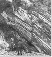 Parallel faulting and bedding details in Ordovician sediments - Mallacoota Airport Beach. |  Chevron folding of Ordovician sediments - Bastion Point. | 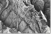 Honeycomb weathering, jointing and quartz veins in Ordovician sediments - Shipwreck Creek. |
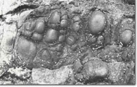 Spheroidal weathering of basic volcanic dyke intruding Ordovician sediments near Betka river. | 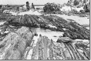 Serrates shore platform with sand veneer Bastion Point. | 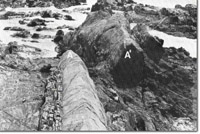 Faulted displacement (A-A'), of sandstone bed in Ordovician sediments - Bastion Point. |
 Recumbent fold - Mallacoota Airport Beach. | 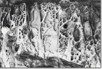 Honeycomb weathering of Ordovician sediments - Seal Creek. | 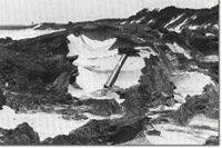 Case hardening of Ordovician sediments - Bastion Point. |
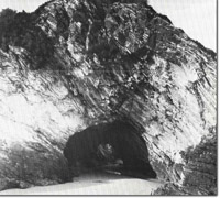 Arch near Betka River. | 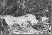 Cobble beach derived from Ordovician sediments - Shipwreck Creek. |  Coastal plateau east of Little Rame Head. Rock stackes (arrowed) at mouth of Shipwreck Creek. |
 Coastal Physiography - Red River to Mallacoota Inlet (from Rosengren, 1978) |
© State of Victoria (Agriculture Victoria) 1996 - 2025.

This work, Victorian Resources Online, is licensed under a Creative Commons Attribution 4.0 licence. You are free to re-use the work under that licence, on the condition that you credit the State of Victoria (Agriculture Victoria) as author, indicate if changes were made and comply with the other licence terms.
The licence does not apply to ‘branding’ or some ‘images or photographs’ that may be owned by third parties. We ask you to seek prior approval to use images using the VRO feedback form. Access to higher quality images can also be provided on request.
This page was last updated on 23/03/2020.