
8722-7 Tamboon Inlet
|
This information has been developed from the publications:
|
Location: | 875190. 20 kilometres south of Cann River | |
Abstract: | Estuarine lagoon, river delta, active dunes. | |
Access: | Tamboon Road from Point Hicks Road. | |
Ownership: | Crown Land (Croajingolong National Park). | |
Geology: | The eastern shoreline of Tamboon is defined by a ridge of Noorinbee Granodiorite, a moderately fine grained black and white granodiorite which forms cliffs and irregular rock platforms along the eastern shoreline. These are further outcrops in the Cann Valley above Reedy Rock. A small enclave of weathered Ordovician sedimentary rock occurs in the Cann Valley above Lake Furnell. Tertiary sands overly the granitic rocks east of Tamboon inlet and to the west are the sands for the barrier formations that extend to Sydenham Inlet. Other Quaternary materials include extensive alluvium and swamp deposits between lake Furnell and Reedy Crrek, silt, sand and gravel in the Cann River delta, an beach and dune sands. | |
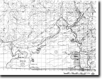
Geomorphology: | Tamboon Inlet consists of five morphological units. 1) The river channel and delta. The Cann River is tidal for several kilometres upstream from Furnell and salt water probably penetrates as fas as the rapids above the junction of reedy Creek. The narrow and deep channel is here fringed by reedswamp which is most extensive at Lake Furnell and in the backswamp and cut-off meander forming O’Meara Lagoon. The delta consists of coarse sand overlying silts and clays and there is one small deltaic island that accumulates sediment during river floods. 2) The northern basin. The main body of the Tamboon Inlet consists of two basins which are separated by a sand bar and a long tapering spit that extends from the western shoreline. The northern basin is saucer-shaped and slopes gradually to a maximum depth of eight metres. This basin. Being relatively isolated from river and tidal inflow, contains the finest sediment material in the inlet. 3) The southern basin. This slopes steeply to a maximum depth of 12 metres. Being more open to river and tidal inflow, the sediments here are coarser and there is a smaller clay fraction than in the northern basin. 4) The eastern channel. A well defined channel lies along the eastern margin of the inlet and may be traced from the river mouth south towards the entrance. The channel is of variable depth averaging two to three metres. The deepest point (8 metres) is in the south where it is constricted between granitic rocks to the east and the active dune mass to the west of the entrance. 5) The entrance. The entrance and the coastline immediately to the east and west are areas of considerable geomorphological interest. The entrance is periodically closed by a sand barrier and after opening it becomes constricted by spit growth from both eastern and western sides that coalesce to re-form the barrier. The height of the barrier is increase by sand deposition from wave to wind action and the water level in the inlet rises until the barrier is breached. Local residents occasionally artificially open an entrance through this barrier. Bluffs and freshwater lagoons now partly filled by sand dunes indicate a former entrance channel that extended two kilometres east to Clinton Rocks Creek. The size of these dunes and the degree of vegetation cover suggests that this channel has not been active for perhaps several hundred years. On the south west of the entrance is a massive active dune formed in part from the re-activation of older vegetated parabolic dune ridges. The dune has an active slip face on the northern and eastern sides and develops a steep sliding face when undercut by tidal flow through the entrance channel. Estimates of forward movement made from aerial photographic interpretation indicate an average rate of 1.2 metres per year for the period 1940 to 1973. It is apparent from the configuration of the entrance that the channel, when open, is deflected to the west and thus undercuts the dune. Some sand eroded in this way washed into the inlet but much is carried out by ebb tide flow and moved back onshore by wave action and blown once more into the dune system. | |
Significance: | State. Tamboon is one of the largest, relatively unmodified estuaries in East Gippsland and is major site for studies of estuaries hydrology and geomorphology. The stratigraphy, soils and vegetation of barrier systems that extend from Tamboon to Sydenham has not been investigated and there has been only preliminary study of the sedimentology of the inlet. The river delta, the long spit that divides the two inlet basins and the active dune west of the entrance are dynamic features of considerable geomorphological interest. | |
Management: | As with all East Gippsland estuaries, the tidal entrance to Tamboon is often restricted or closed by sand barriers or spits thus reducing outflow and tidal ventilation. Artificial opening of the entrance increases the salinity over the inlet and causes die-back of fringing vegetation and other ecological changes. On these grounds artificial opening should be prohibited. Further extensive clearing and logging of Cann Valley and the slopes of the inlet may increase the amount of fine grained sediment delivered to the inlet, thus increasing the turbidity of the waters and the rate of sedimentation in the northern basin. There is little justification for artificially stabilising the active dune west of the entrance as the entire barrier shoreline has a history of dune movement that pre-dates European settlement. This is particularly the case if Marram grass is used as a sand binding agent, as this is an exotic species and there seems little need to further introduce it on the East Gippsland coast. | |
References: | Rosengren, N. J. 1978. The Physiography of Coastal Dunes, East Gippsland, Victoria. M. A. Thesis (Unpub.), University of Melbourne | |
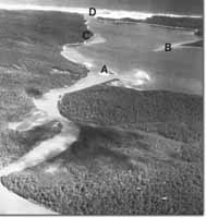 Lower Cann River and Tamboon Inlet - River delta islands (A). Sandy spit (B). Granite shoreline (C). Entrance (D) |
© State of Victoria (Agriculture Victoria) 1996 - .

This work, Victorian Resources Online, is licensed under a Creative Commons Attribution 4.0 licence. You are free to re-use the work under that licence, on the condition that you credit the State of Victoria (Agriculture Victoria) as author, indicate if changes were made and comply with the other licence terms.
The licence does not apply to ‘branding’ or some ‘images or photographs’ that may be owned by third parties. We ask you to seek prior approval to use images using the VRO feedback form. Access to higher quality images can also be provided on request.
This page was last updated on .