
8722-4 Mueller River Estuary
|
This information has been developed from the publications:
|
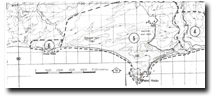
Location: | 045160. 1 kilometre east of Point Hicks Road. | 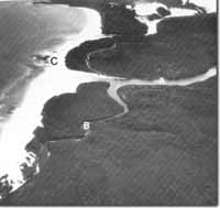 Mueller River Estuary (A). Camp Creek (B). Outcrop of Ordovician sediments (C). |
Abstract: | Drowned River Valley. | |
Access: | Point hicks Road and unformed road. | |
Ownership: | Crown Land (Croajingolong National Park) | |
Geology: | Upper Ordovician sandstones, shales and slates outcrop in cliffs along the lower valley of the Mueller River and on the low headland that separates the Mueller from the Thurra River. The sediments strike north-south and are in places tightly folded. A thin capping of consolidated, well bedded dune sands overlies the Ordovician rocks and these are well exposed along the Camp Creek arm of the Mueller estuary. | |
Geomorphology: | The estuary is the drowned valley of the Mueller River which is deeply incised into the low coastal plateau. The valley is narrow and ‘v’-shaped and is generally aligned along the strike of the Ordovician rocks. The estuary is the subject to tidal influence for approximately 3 kilometres although salinity levels are low as the entrance sloping banks the intertidal area is small. The estuary os the Mueller and Camp Creek is fringed by a mixed Juncus maritimus and Phragmites australis marsh backed by Melaleuca ericifolia. | |
Significance: | Regional. The area has been little modified and is important ant example of a small drowned valley system. In comparison with adjacent estuaries (Wingan, Red River) which have extensive granitic areas in their catchments, the Mueller is developed mainly on sedimentary rocks. (Ordovician and Tertiary). This allows comparisons to be made between rates of chemical weathering by hydrochemical studies of the estuarine waters. The validity of these studies is related to the limited disturbance of the catchments. Apart from forest operations, there has been no major clearing and no agricultural land use in the catchment of the Mueller and Red rivers. | |
Management: | The broad issue of catchment management is outlined above. In addition, power boating on, an uncontrolled vehicle access to, the Mueller is causing erosion of the banks and valley slopes and pollution of the estuary waters. Camp sites should be located well away from the estuary shores and sullage and sewage from any larger camp grounds that are constructed should be drained away from the Mueller River. Power boating should be prohibited on the estuary. | |
© State of Victoria (Agriculture Victoria) 1996 - .

This work, Victorian Resources Online, is licensed under a Creative Commons Attribution 4.0 licence. You are free to re-use the work under that licence, on the condition that you credit the State of Victoria (Agriculture Victoria) as author, indicate if changes were made and comply with the other licence terms.
The licence does not apply to ‘branding’ or some ‘images or photographs’ that may be owned by third parties. We ask you to seek prior approval to use images using the VRO feedback form. Access to higher quality images can also be provided on request.
This page was last updated on .