
8622-8 Cliff at Frenchs Narrows
This information has been developed from the publications:
|
Location: | 385153. Four kilometres east of Marlo. | 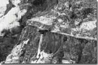 Early Pleistocene sediments in Snowy River bluffs at Frenchs Narrows. |
Abstract: | Cliff section of Tertiary/Quaternary sediments. | |
Access: | Marlo – Cape Conran Road. | |
Ownership: | Crown Land. | |
Geology/Geomorphology: | East from Marlo, the coastal terrace terminates abruptly as a degraded cliff in front of which lies the lagoon and barrier complex at the Snowy River mouth. Opposite Frenchs Narrows and at the other localities to the west are clear exposures of bedded, poorly consolidated sediments, dominated by clays and silts but including some fine sand layers. At least two main sequences occur, that nearer to Marlo being probably Tertiary (Pliocene), non-marine sands and clays. At Frenchs Narrows, the sediments are more distinctly stratified and display a variety of bedding forms and depositional structures indicative of fluvial origin. These beds are more likely to be of Pleistocene age and possibly represent a deltaic faces of the Snowy and Brodribb Rivers. Ferruginous weathering enrichment along bedding and fracture planes causes thin bands to project prominently either horizontally, or vertically, from the cliff face. The cliff is an abandoned marine cliff initiated during a Pleistocene higher sea level phase and briefly re-activated during the Holocene marine transgression prior to the development of the barriers and lagoons at the Snowy river mouth. Unlike areas west of the Snowy River, no older barrier formation occurs in front of this cliffed section. East of Frenchs Narrows, the cliff is lower and less distinct as in several places it has been surmounted by parabolic dunes. | |
Significance: | Regional. Coastal cliff exposures of Tertiary and consolidated Pleistocene sediments are rare in East Gippsland and this site represents one of the best such outcrops east of the Gippsland lakes. | |
Management: | Weathering, mass wasting and vegetation growth is converting the cliff to a coastal bluff and obscuring the outcrop. Selected sites could be periodically excavated to maintain the exposure. | |
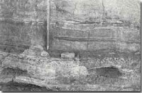 Detail of bedding - Frenchs Narrow (plate 42). |  Sites 8622 7 to 16 |
© State of Victoria (Agriculture Victoria) 1996 - .

This work, Victorian Resources Online, is licensed under a Creative Commons Attribution 4.0 licence. You are free to re-use the work under that licence, on the condition that you credit the State of Victoria (Agriculture Victoria) as author, indicate if changes were made and comply with the other licence terms.
The licence does not apply to ‘branding’ or some ‘images or photographs’ that may be owned by third parties. We ask you to seek prior approval to use images using the VRO feedback form. Access to higher quality images can also be provided on request.
This page was last updated on .