
8622 (Part 8522)-12 Corringle Swamp
|
This information has been developed from the publications:
|
Location: | 340150 (8622) to 270160 (8522). Two kilometres west of Marlo. | 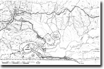 Sites 8622 7 to 16 |
Abstract: | Former entrance of Snowy River, swamps, barrier sand and dune ridges. | |
Access: | Boat across Snowy River from Marlo. Lake Corringle Road. | |
Ownership: | Part Crown Land, part private land | |
Geology/Geomorphology: | South of Lake Corrinlge is an extensive wetland that at one time was an open water area of the Snowy River estuary. The estuary was enclosed by low sand barrier islands separated by tidal inlets but these islands have coalesced to form a continuous barrier and the Snowy River outlet has been deflected successively eastward. The position of three former tidal entrances is shown. The estuarine basin had been partly filled by sediments deposited by river floods and by sand washed over blown from the coastal barriers – Lake Corringle is a remnant of the former larger estuarine lagoon. An unusual pattern of low, closely spaced curving ridges (concentric ridges) surrounds several of the small lagoons south of Lake Corringle. Although the process of ridge formation is not clear, they probably relate to stages of infilling of the lagoon due to encroachment of reedswamp. | |
Significance: | Regional. The area contains several features that indicates stages in the evolution of the western side of the Snowy River estuary. The concentric ridges and relict washover sands do not occur on the east of the Snowy Valley. | |
Management: | Most relief features described are low and would be destroyed if drainage and land reclamation works proceed. | |
Morphological map of Corringle Swamp
© State of Victoria (Agriculture Victoria) 1996 - .

This work, Victorian Resources Online, is licensed under a Creative Commons Attribution 4.0 licence. You are free to re-use the work under that licence, on the condition that you credit the State of Victoria (Agriculture Victoria) as author, indicate if changes were made and comply with the other licence terms.
The licence does not apply to ‘branding’ or some ‘images or photographs’ that may be owned by third parties. We ask you to seek prior approval to use images using the VRO feedback form. Access to higher quality images can also be provided on request.
This page was last updated on .