
8524-12 Block Streams - Cobberas, Big Hill, Mount Wombargo
|
This information has been developed from the publications:
|
Location: | (a) 015238. Surveyors Creek on western slopes of Mount Cobberas No. 2. (b) 032208. Amphitheatre south of Cleft Peak and Middle Peak. (c) North-west facing slope of Big Hill. (d) 050103, 050120. Southern and western slopes of Mount Wombargo. | 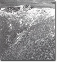 Mount Cobberas No. 2. Block stream at Surveyors Creek. |
Abstract: | Periglacial road rivers. | |
Access: | (a) Tin Mine Road, (b) Cobberas Track, (c) & (d) Black Mountain Road | |
Ownership: | Crown Land. | |
Geology/Geomorphology: | These localities clearly display the major characteristics of the Pleistocene block streams that reach maximum development in Victoria on the ryhodacites of the Snowy River Volcanics in the Cobberas- Wombargo area. The block streams are accumulations of unsorted, angular boulders, usually 10 cm to one metres in length, but with some blocks in excess of two metres width that weigh over several tonnes. Many of the larger blocks are bounded by well preserved joints plane facets. The block streams lie on steep slopes (18º to 26º), are up to 200 metres in length and in places are up to 50 metres wide, generally originating at low bluffs in outcrops of rhyodacites. The larger block- streams broadly resemble river systems in plan view with one or more tributary rock rivers converging to produce a wide treeless area. On lower slopes, the block streams are largely obscured by soil accumulation and vegetation growth, hence the area covered by them is readily apparent on aerial photographs. Several aspects of the geomorphology of the Cobberas/ Wombargo area suggest that evidence for Pleistocene glaciation is lacking, and that previous periglacial weathering regimes are responsible for the production of the rock rivers. | |
Significance: | National. The area contains the most extensive periglacial block stream on the Australian mainland- their scale, diversity of form and degree of preservation are unique in Victoria. The site is of major interest for geomorphological and botanical studies, eg. Rates of soil and vegetation development on these Pleistocene relict landforms. | |
Management: | Part of the interest in the sites described lies in the distribution and not only the configuration of isolated features. Disturbance to the structure and fabric of the block streams, which may initiate slope failure, should be avoided. | |
References: | Talent,J.A. 1965a 'Geomorphic forms and processes in the Highlands of Eastern Victoria', Proc. R. Soc. Vict., 87(1) :119-134. Webster , 1974. | |
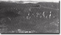 Moscow Peak. Block streams (arrowed). | 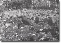 Mount Wombargo. Detail of block stream. | 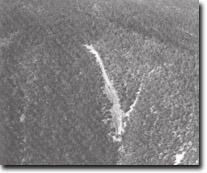 Mount Wombargo. Block stream. |
© State of Victoria (Agriculture Victoria) 1996 - .

This work, Victorian Resources Online, is licensed under a Creative Commons Attribution 4.0 licence. You are free to re-use the work under that licence, on the condition that you credit the State of Victoria (Agriculture Victoria) as author, indicate if changes were made and comply with the other licence terms.
The licence does not apply to ‘branding’ or some ‘images or photographs’ that may be owned by third parties. We ask you to seek prior approval to use images using the VRO feedback form. Access to higher quality images can also be provided on request.
This page was last updated on .