
8523-25 The East Buchan Area
Sites 8523 (8522) 16 to 30 - The Buchan/Murrindal Limestone Basin
This information has been developed from the publications:
|
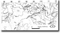
Location: | 085480. Near the junction of the Buchan and Murrindal Rivers, East Buchan. | 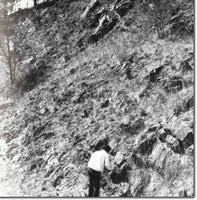 East Buchan. Spring Creek Member of Buchan Caves Limestone. |
Abstract: | Exposures of the Spring Creek Member, surface karst features and important caves. | |
Access: | Private road, north of the Buchan - Orbost Road. | |
Ownership: | Private land with small Crown River Reserve. | |
Geology: | The transitional beds separating the Snowy River volcanics from the dolomitic facies of the Buchan Caves Limestone are well exposed in cliffs on the Buchan River, near its junction with the Murrindal River and downstream toward Back Creek. The member varies greatly in thickness and the sandy phase which often separates the lowest limestone bed from the Snowy River Volcanics in other areas, is largely absent from this area. Highly fossiliferous limestone is found within a short distance of the upper beds of the Snowy River Volcanics. | |
Geomorphology: | Solution doline surface karst topography occurs on the south side of the Buchan River near its junction with the Murrindal River. The Buchan River, upstream from this locality has cut substantial river cliffs in limestone. A large number of cave systems occur in these cliffs, the entrance to which commonly occur on the undercut bank of the river meanders. The most significant cave is Mabel Cave (EB-1). This is an intermittent stream outflow cave, and although the hydrology of the area is unknown, the volume of stream discharge suggests a large drainage basin. Several entrances to this cave occur in the Buchan River cliffs and these open into large chambers, one of which descends below the water table. In addition, this cave provides a refuge site for the bat, Miniopterus Schreibersii and contains a substantial fossil bone deposit. | |
Significance: | Regional. The area shows good exposures of the Spring Creek Member, examples of surface karst and contains several significant caves. | |
Management: | Insufficient information on the subsurface hydrology is available to allow the formation of detailed management prescriptions for this cave area. The general guidelines outlined apply to this site. | |
References: | Tiechert, C. and Talent, J.A. 1958. 'Geology of the Buchan area, East Gippsland', Mem. geol. Surv. Vict., 21: 1-56. Matthews, P.G. (ed) 1968. Speleological Handbook. Victorian Speleological Association. | |
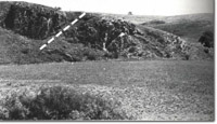 East Buchan Thrust, (dotted line indicates fault plane). | 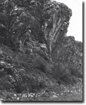 East buchan Thrust Fault. Detail of folding. | 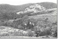 Cliffs (A) in Buchan Vaces Limestone along Buchan River. |
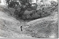 Blind Valleu leading to Wilson Cave (EB-4). | 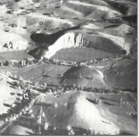 East Buchan Thrust Fault area. Thrust Fault (A), Buchan River (B). Blind valley (C). Folds (D). Old course of Tara Creek (dotted). |
© State of Victoria (Agriculture Victoria) 1996 - .

This work, Victorian Resources Online, is licensed under a Creative Commons Attribution 4.0 licence. You are free to re-use the work under that licence, on the condition that you credit the State of Victoria (Agriculture Victoria) as author, indicate if changes were made and comply with the other licence terms.
The licence does not apply to ‘branding’ or some ‘images or photographs’ that may be owned by third parties. We ask you to seek prior approval to use images using the VRO feedback form. Access to higher quality images can also be provided on request.
This page was last updated on .