
8523-22 APM Quarry - Rocky Camp
Sites 8523 (8522) 16 to 30 - The Buchan/Murrindal Limestone Basin
This information has been developed from the publications:
|
Location: | 060528. 7 kilometres north of Buchan. | 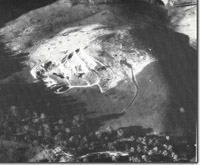 APM quarry, Rock Camp. |
Abstract: | Exposures of Rocky Camp Member. | |
Access: | Buchan - Murrindal Road. | |
Ownership: | Private. | |
Geology: | The quarry is cut on three levels in a massively bedded limestone deposit. Fossils including stromatoporoids, tabulate and rugose corals with Receptacultes (a sponge-like fossil) as a common associate occur frequently with occasional nautiloids and bryozoa. | |
Significance: | Regional. Best exposure of the Rocky Camp Member. | |
Management: | The significance of the site is enhanced by the maintenance of a clear face in the Quarry. | |
References: | Tiechert, C. and Talent, J.A. 1958. 'Geology of the Buchan area, East Gippsland', Mem. geol. Surv. Vict., 21: 1-56. | |
© State of Victoria (Agriculture Victoria) 1996 - .

This work, Victorian Resources Online, is licensed under a Creative Commons Attribution 4.0 licence. You are free to re-use the work under that licence, on the condition that you credit the State of Victoria (Agriculture Victoria) as author, indicate if changes were made and comply with the other licence terms.
The licence does not apply to ‘branding’ or some ‘images or photographs’ that may be owned by third parties. We ask you to seek prior approval to use images using the VRO feedback form. Access to higher quality images can also be provided on request.
This page was last updated on .