
8222-8 Macalister River Floodplain
|
This information has been developed from the publications:
|
Location: | Area between Easting 950 and 970; Northing 980 and 020. Three to five kilometres north of Maffra. | 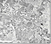 Macalister River near Maffra. Floodplain complex of abandoned meanders and point bars (arrowed) |
Abstract: | Flood plain landforms. | |
Access: | From Maffra Lake Park Road or Bellbird Corner Road. | |
Ownership: | Private land. | |
Geomorphology: | The present flood plain of the Macalister River lies between higher level terrace deposits east of Lake Glenmaggie. The flood plain is of the alluvial meander type with a highly sinuous channel form giving rise to numerous cut-off meanders. These display various stages of swamp reclamation. Fences and point bar deposits are prominent on those meander reaches not subject to intensive agriculture. | |
Significance: | Regional. The extent of meander cut-off development is much higher than for other East Gippsland streams. This is possibly due to the greater length of flood plain on the Macalister River. | |
Management: | The flood plain has been extensively modified by agricultural activities. However, continued course changes by the Macalister River should maintain the development of the fluvial features on the flood plains. | |
© State of Victoria (Agriculture Victoria) 1996 - .

This work, Victorian Resources Online, is licensed under a Creative Commons Attribution 4.0 licence. You are free to re-use the work under that licence, on the condition that you credit the State of Victoria (Agriculture Victoria) as author, indicate if changes were made and comply with the other licence terms.
The licence does not apply to ‘branding’ or some ‘images or photographs’ that may be owned by third parties. We ask you to seek prior approval to use images using the VRO feedback form. Access to higher quality images can also be provided on request.
This page was last updated on .