
Toorongo (To)
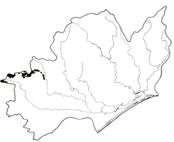 | Area: 137 sq. km (0.7%). This land system occurs below the subalpine tract in the western part of the East Victorian Uplands, on high-level plateaux formed on granodiorites and other plutonic rocks. The topography is hilly to gently undulating and the overall slope of the plateaux are low, possibly reflecting a dissected prior land surface. The dissection pattern is based on jointing in the parent rock and colluvial accumulations and boggy, alluvial floors characteristically occur along the etched-out joint lines. The climate is very humid and this is reflected in the vegetation. | 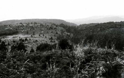 Rounded hills and steep slopes along incised drainage lines. The control of the drainage pattern by joining is readily apparent. |
| The humid climate, gentle slopes and parent rock that is easily weathered combine to produce deep, brown or red, well-structured, acidic soils. The dense vegetation cover has tended to produce deep topsoils rich in organic matter. The subsoil colours are usually bright shades of red, brown or yellowish brown due to the good internal drainage. Young soils, such as those along drainage lines, often contain prominent muscovite mica. The vegetation is mainly layered open forest III or IV. Closed forest III of Nothofagus cunninghamii occurs within some drainage corridors and open heath grows in swampy areas. | ||
| CLIMATE Rainfall, mean (mm) Temperature, mean (°C) Seasonal growth limitations | Annual 1200 - 1800; lowest January or February (70 - 100), highest August or September (130 - 180) Annual 8 - 12; lowest July (3 - 7), highest February (16 - 20) Temperature <10°C (av.): April - October Rainfall < potential evapotranspiration: February; frequent winter snow |
| GEOLOGY Age, lithology | Devonian granodiorites and granites (Toorongo and Baw Baw Grandiorites and Tynong Granites) |
| PHYSIOGRAPHY Landscape Elevation range (m) Relative relief (m) Drainage pattern Drainage density (km/km2) | Undulating to high-level hilly plateaux with approximately concordant crests and joint-based dissection 480 - 1120 120 - 420 Rectangular 1.6 |
| PRESENT LAND USE | Mostly uncleared: hardwood forestry (ash timber); apiculture |
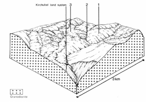 | 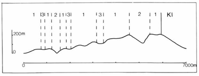 |
| LAND COMPONENT Percentage of land system Diagnostic features | 1 65 Slopes, ridges and low hills based on fine jointing patterns, and colluvial footslopes | 2 20 Steep slopes of incised valleys | 3 15 Treeless flats, often with peat bogs, mainly along streams |
| PHYSIOGRAPHY Slope %, typical and (range) Slope shape | Variable; <25, (5- 60) Convex, some straight | Variable; >25, (20- 70) Concave | <1, (0- 2) Straight |
| SOIL | |||
| Parent material | Granodiorite and granite | Locally derived alluvium; plant remains | |
| Description | Black to dark brown sandy clay loam to sandy loam grading into yellowish brown to reddish brown clay loam to light clay | Mainly black organic sandy loams grading into grey sandy clay loams, in places with shallow peaty layers. Some micaceous undifferentiated greyish brown or yellowish brown mineral soils of variable texture | |
| Classification | Brown and Red Earths/Krasnozems Gn4.11, Gn4.34, Gn2.21, Um6.12, Uc1.21, Urn 1.44 | Mainly Humic Gleys, probably also some Alluvial Soils Um5.52, O | |
| Surface texture | Sandy clay loam to sandy loam | Variable; sandy clay loam to sand | |
| Surface consistence | Soft when dry, very friable when moist | Very friable when moist | |
| Depth (m) | >2.0 | >2.0 | |
| Nutrient status | Moderate | Moderate | |
| Available soil water capacity | Moderate | Moderate | |
| Perviousness to water | Rapid | Rapid | |
| Drainage | Good | Very poor | |
| Exposed stone (%) | <5 | 0 | |
| Sampled profile number | - | - | |
| NATIVE VEGETATION Structure of vegetation and characteristic species of dominant stratum (+ Predominant species) | Layered open forest III, IV: E. delegatensis+, with or without E. nitens, at higher elevations grading to E. nitens+ or E. regnans+, with or without E. cypellocarpa, at lower elevations. Nothofagus cunninghamii in understorey mainly in Mount Baw Baw and Mount Toorongo areas | Open forest III: E. regnans with or without N. cunninghamii Closed forest II, often ferny: N. cunninghamii | Open heath: Baeckea gunniana+, Epacris paludosa+, Richea continentis+ Bogs with Carex spp.+, Empodisma minus, Sphagnum sp.+ |
|
|
|
|
| ||
|
|
| ||||
— reduction in leaf area, rooting depth and/or perenniality |
resulting in increased deep percolation |
|
|
|
|
|
|
|
|
2; high |
|
burning, road and other earth-moving activities, trafficking by stock. |
and sediment load. |
|
With Reduced infiltration |
Sheet and rill erosion |
2,3; high 1; moderate - high 2; high |
Uncommon |
As for sheet and rill erosion above |
Increased spring and decreased summer stream flow |
|
|
|
3; moderate |
|
|
|
| ||||||
© State of Victoria (Agriculture Victoria) 1996 - .

This work, Victorian Resources Online, is licensed under a Creative Commons Attribution 4.0 licence. You are free to re-use the work under that licence, on the condition that you credit the State of Victoria (Agriculture Victoria) as author, indicate if changes were made and comply with the other licence terms.
The licence does not apply to ‘branding’ or some ‘images or photographs’ that may be owned by third parties. We ask you to seek prior approval to use images using the VRO feedback form. Access to higher quality images can also be provided on request.
This page was last updated on .