
Stewart (Sw)
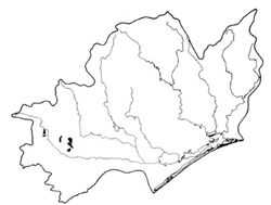 | Area: 41 sq. km (0.2%) Extremely silty areas of Tertiary and adjoining Devonian sediments have been mapped in Stewart land system. These areas have rounded hills with moderate slopes and some undulating terrain. Broad alluvial floors in concave valleys are fed by seepage from the hills and carry water all year. These floors are characteristically swampy, with peaty surface materials. A diagnostic feature of this land system is the heathy nature of the vegetation which occurs on most of the slopes despite the relatively high rainfall. The silty and clayey parent materials and the moderate to gentle slopes have promoted the development of duplex and gradational soils. These have been strongly leached and are strongly to moderately acidic. The very high silt contents often result in poor internal drainage and this, along with the common, extremely low nutrient contents, leads to the heathy vegetation. Land with moderate slopes and slowly pervious soils is likely to cause a higher proportion of surface run-off, increasing the erosion risk. The badly-eroding road batters indicate that the soils are highly susceptible to erosion. The vegetation is often a heathy open woodland I or heathy woodland I, though open forest II occurs on better sites. Well-drained alluvial terraces support open forest II or III, often layered or shrubby while swampy drainage areas have a closed scrub or shrubby woodland I. | 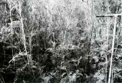 Closed scrub of Melaleuca squarrosa (scented paper-bark) and Gleichenia microphylla (scrambling coral fern) growing in a seepage area |
| CLIMATE Rainfall, mean (mm) Temperature, mean (°C) Seasonal growth limitations |
Annual 700 - 1200; lowest January or February (40 - 70), highest August or October (90 - 120) Annual 12 - 14; lowest July (8 - 10), highest February (19 - 21) Temperature <10°C (av.): May - September Rainfall < potential evapotranspiration: November – March |
| GEOLOGY Age, lithology | |
| PHYSIOGRAPHY Landscape Elevation range (m) Relative relief (m) Drainage pattern Drainage density (km/km2) |
Rounded hills and undulating terrain with broad swampy valley floors 100 - 280 60 - 120 Dendritic 1.8 |
| PRESENT LAND USE |
Minor proportion cleared: grazing of beef and dairy cattle on improved pastures |
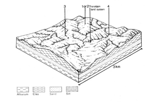 | 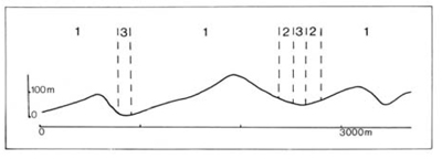 |
| LAND COMPONENT Percentage of land system Diagnostic features | 1 45 Slopes with very silty soils and heathy woodlands | 2 35 Slopes with silty soils and forests | 3 15 Swampy drainage depressions | 4 5 Well drained terraces |
| PHYSIOGRAPHY Slope %, typical and (range) Slope shape | 15 - 20, (5 - 30) Convex and concave | 15 - 20, (5 - 30) Convex and concave | <1, (0 - 2) Straight | <2, (0 - 5) Straight but uneven |
| SOIL | ||||
| Parent material | Silt and clay; minor sandstone, siltstone and mudstone | Alluvium and plant debris | Alluvium | |
| Description | Dark greyish brown sand to silty loam topsoil, abrupt or gradual change to mottled, yellowish brown or yellow, generally blocky structured clay (sometimes sandy clay loam) subsoil | Black organic loam over variable mottled grey mineral layer; shallow peat in places | Single observation — probably undifferentiated brown stratified soils, often mottled at depth | |
| Classification | Yellow Podzolic Soils, Yellow Earths Dy3.41, Dy5.21, Gn4.81 | Humic Gleys, Acid Peats Uc1.41, O | Alluvial Soils/Yellow Earths Um2.3- | |
| Surface texture | Sand to silty loam | Loam | - | |
| Surface consistence | Soft to hard when dry | Friable to firm when moist | - | |
| Depth (m) | >1.0 | >2.0 | >2.0 | |
| Nutrient status | Extremely low | Low to moderate | Low to moderate | Low to moderate |
| Available soil water capacity | Low to moderate | Low to moderate | Moderate to high | Variable |
| Perviousness to water | Slow | Slow | Variable | Variable |
| Drainage | Poor to somewhat poor | Somewhat poor to moderately good | Very poor to poor | Somewhat poor, in places good |
| Exposed stone (%) | 0 | 0 | 0 | 0 |
| Sampled profile number | 53 | - | - | - |
| NATIVE VEGETATION Structure of vegetation and characteristic species of dominant stratum (+ Predominant species) | Heathy open woodland I, heathy woodland I: E. consideniana+ and/or E. cephalocarpa+ | Open forest II: E. consideniana+; E. obliqua+, E. radiata+ in areas of better drainage | Closed scrub: Melaleuca squarrosa Shrubby woodland I: E. ovata+, E. radiata, with an understorey of Melaleuca squarrosa and/or Leptospermum spp. | Limited data — probably shrubby or layered open forest II, III: E. obliqua+ with E. viminalis and E. radiata observed; E. ovata presumed |
|
|
|
|
| ||
|
|
| ||||
— reduction in leaf area, rooting depth and/or perenniality |
resulting in increased deep percolation |
|
|
|
|
|
|
|
|
|
|
|
|
|
With Reduced infiltration |
Sheet and rill erosion |
3; high 1,2; moderate - high |
Uncommon |
As for sheet and rill erosion above |
Increased flash flows |
|
|
Streambank erosion |
4; moderate |
Uncommon |
As for sheet and rill erosion above |
Increased sediment load |
| ||||||
© State of Victoria (Agriculture Victoria) 1996 - .

This work, Victorian Resources Online, is licensed under a Creative Commons Attribution 4.0 licence. You are free to re-use the work under that licence, on the condition that you credit the State of Victoria (Agriculture Victoria) as author, indicate if changes were made and comply with the other licence terms.
The licence does not apply to ‘branding’ or some ‘images or photographs’ that may be owned by third parties. We ask you to seek prior approval to use images using the VRO feedback form. Access to higher quality images can also be provided on request.
This page was last updated on .