
Sale (Se)
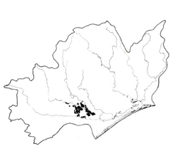 | Area: 163 sq. km (0.8%) Most of the later Pleistocene terrace is mapped as Sale land system. The terrace is almost flat and it retains features developed during its period as a flood plain, including fluviatile forms and soils. The soils are more pervious than the underlying materials and incipient poor drainage, exacerbated by irrigation, is a feature. Waterlogging is relatively severe on the plains near Bairnsdale and here it is accompanied by subsoil sodicity. As soil parent materials are mainly clayey and silty and as drainage tends to be poor, leaching, weathering and other processes have not caused significant vertical differentiation in the profiles. Widespread occurrence of mottling is due to periodic waterlogging. Inadequate leaching and saline groundwaters probably account for the alkalinity of the deep subsoils and the mild acidity of the topsoils. The salinity hazard is rated as moderate. The native vegetation, probably mainly a grassy open forest II dominated by E. tereticornis, has been almost entirely cleared. | 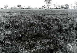 Flat, relict alluvial plains with remnants of Eucalyptus teteticornis (forest red gum) open forest |
| CLIMATE Rainfall, mean (mm) Temperature, mean (°C) Seasonal growth limitations | Annual 500 - 800; lowest July (30 - 50), highest October (50 - 80) Annual 12 - 14; lowest July (8 - 10), highest February (19 - 21) Temperature <10°C (av.): June - August Rainfall < potential evapotranspiration: November – March |
| GEOLOGY Age, lithology | Upper Pleistocene alluvium of gravels, sands, silts and clays |
| PHYSIOGRAPHY Landscape Elevation range (m) Relative relief (m) Drainage pattern Drainage density (km/km2) | Almost flat alluvial plains 40 0 - 5 Dendritic 0.5 |
| PRESENT LAND USE | Mostly cleared: grazing of beef and dairy cattle on improved irrigated pastures; cropping (limited) Minor proportion uncleared: some apiculture |
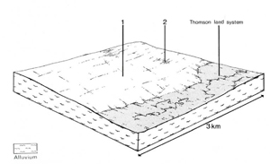 | 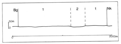 |
| LAND COMPONENT Percentage of land system Diagnostic features | 1 85 Broad, almost flat, relict plains | 2 15 Slightly depressed, less well drained areas |
| PHYSIOGRAPHY Slope %, typical and (range) Slope shape | 1, (0 - 2) Straight | <1, (0 - 1) Straight to slightly concave |
| SOIL | ||
| Parent material | Mainly silt and clay but coarser alluvial materials occur in places | |
| Description | Dark greyish brown loam to clay loam topsoil, often mottled over mottled dark brown or dark yellowish brown clay subsoil with blocky structure; alkaline reaction at depth. Weak duplex tendency common | Mottled dark greyish brown clay loam to light clay topsoil grading into mottled dark brown or dark yellowish brown blocky clay subsoil; moderately alkaline at depth |
| Classification | Wiesenboden/Solodic Soils, Wiesenboden Db2.23, Db4.23, Dy3.23, Dd2.23, Gn3.56 | Humic Gleys, some Wiesenboden Gn3.23, Gn3.53, Db2.13 |
| Surface texture | Loam to clay loam | Clay loam to light clay |
| Surface consistence | Slightly hard to hard when dry | Firm when moist |
| Depth (m) | >2.0 | >2.0 |
| Nutrient status | Moderate | Moderate to high |
| Available soil water capacity | Moderate | Moderate |
| Perviousness to water | Slow | Slow |
| Drainage | Somewhat poor | Poor to somewhat poor |
| Exposed stone (%) | 0 | 0 |
| Sampled profile number | 69 | - |
| NATIVE VEGETATION Structure of vegetation and characteristic species of dominant stratum (+ Predominant species) | Grassy open forest II: E. tereticornis+ Clearing has made it difficult to determine other tree species which may have grown in association | |
|
|
|
|
| ||
|
|
| ||||
— reduction in leaf area, rooting depth and/or perenniality |
resulting in: a) increased deep percolation b) raised watertable |
Nutrient loss Waterlogging Salting |
Not determined 1; low 2; moderate 1; low 2; moderate |
Not determined Common: seasonal Common |
Removal of trees Reduced plant-water use in catchment Reduced plant-water use in catchment |
Increased movement of water to groundwater Increased ponding of water in lower areas Increased salting in lower areas |
|
|
|
|
|
|
|
|
With Reduced infiltration |
Waterlogging |
2; high 1; low 2; moderate |
Common; seasonal |
As for structure decline above |
Increased ponding of water in lower areas |
|
|
|
channels or streams |
|
|
|
| ||||||
© State of Victoria (Agriculture Victoria) 1996 - .

This work, Victorian Resources Online, is licensed under a Creative Commons Attribution 4.0 licence. You are free to re-use the work under that licence, on the condition that you credit the State of Victoria (Agriculture Victoria) as author, indicate if changes were made and comply with the other licence terms.
The licence does not apply to ‘branding’ or some ‘images or photographs’ that may be owned by third parties. We ask you to seek prior approval to use images using the VRO feedback form. Access to higher quality images can also be provided on request.
This page was last updated on .