
Maffra 1 (M1)
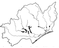 | Area: 161 sq. km (0.8%) This land system occurs on the modern river flood plains that, whilst having an active flood regime, are located above the levels containing major river channels. These alluvial plains have complex patterns of irregular and anastomosing flow paths and channels, with many small flanking levees and intervening clay flats. The land forms and materials of the flood plains within the different stream systems vary, due to differences in flow regime and catchment lithology. Surface materials are mostly clayey and pervious but may be silty or sandy, particularly in the east. Also, in some upstream tracts such as those of the Mitchell and Macalister Rivers, reddish levee materials with coarser textures and relatively free drainage predominate. The deposition of these coarser sediments may reflect the greater competence of the streams where they emerge from the East Victorian Uplands. Some of these regional differences are identified at component level. | 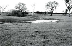 Poorly drained depressions on the river flood plain are characteristic of Maffra I land system. |
| Soils are variable due mainly to differences in soil drainage and in the length of time since alluvial deposition. Deposition is still occurring in some areas but probably ranges up to about 10,000 years ago in others. The river terraces usually have an abundant supply of moisture derived from relatively high water tables and periodic flooding, although the rainfall is low to moderate. Abundant moisture and youthful clayey and silty parent materials with moderate to high levels of plant nutrients has generally meant a high biomass production. As a result most of the older soils have high levels of organic matter. Where drainage is good, these soils have developed crumb structure and friable topsoils in addition to accumulating organic matter. Where waterlogging is common, the soils may be strongly mottled throughout the profile or in the lower horizons only. Very young soils (components 3 and 5) and those where there is lower available moisture due to greater depths to the water table (component 4) have accumulated less organic matter. Brown soils with incomplete development and even younger brown soils with negligible development of structure and colour differentiation, are particularly prevalent along the Tambo and Nicholson Rivers. Mature reddish soils with structureless subsoils and with blocky-structured alkaline subsoils appear to be typical of upstream levees and outwash fans, possibly because coarser sediments and greater depth to water table lead to oxidation of minerals as well as humus. The soils are generally fertile and have a low erosion hazard but they are susceptible to compaction, particularly when wet. A low salinity hazard, which may increase to moderate in localised areas exists in the area between Valencia Creek and Lake Wellington due to moderately deep groundwater of low to moderate salinity. The native vegetation, probably an E. tereticornis grassy open forest 11. has been almost entirely removed. | ||
| CLIMATE Rainfall, mean (mm) Temperature, mean (°C) Seasonal growth limitations | Annual 500 - 800; lowest July (30 - 50), highest October (50 - 80) Annual 12 - 14: lowest July (8 - 10), highest February (19 - 21) Temperature <10°C (av.): June - August Rainfall < potential evapotranspiration: November - March |
| GEOLOGY Age, lithology | Holocene alluvium of clays, silts and sands |
| PHYSIOGRAPHY Landscape Elevation range (m) Relative relief (m) Drainage pattern Drainage density (km/km2) | Active alluvial plains with a complex of levees. ephemeral flow paths and channels 20 - 60 0 - 5 Irregular and braided 2.6 |
| PRESENT LAND USE | Cleared: grazing of beef and dairy cattle on improved, often irrigated pastures; some cropping: some apiculture |
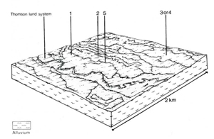 | 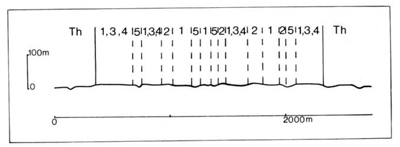 |
| LAND COMPONENT Percentage of land system Diagnostic features | 1 35 Flood plains with better subsoil drainage | 2 15 Flood plains with poorer subsoil drainage (mainly Thomson River and Freestone Creek) | 3 15 Flood plains with youthful undifferentiated soils (mainly Tambo and Nicholson Rivers) | 4 30 Low levees and undulating outwash areas, with either reddish (upstream parts of flood plains) or greyish brown soils | 5 5 Ephemeral channels and flowpaths, often poorly drained |
| PHYSIOGRAPHY Slope %, typical and (range) Slope shape | I. (0 - 3) Straight but uneven | 2,(0-4) Straight | 1, (0 - 3) Straight but uneven | 2, (0 - 4) Convex, some concave | 1, (0 - 5) Concave |
| SOIL | |||||
| Parent material | Mainly silty and clayey alluvium; some sandy sediments | ||||
| Description | Mainly black clay loam topsoil grading into dark brown or reddish brown clay subsoil, often mottled at depth and neutral to alkaline | Mainly very dark grey to dark brown clay loam sometimes mottled, grading into dark grey to dark brown mottled clay subsoil | Limited observations — very dark greyish brown sandy loam to silty loam topsoil grading into similar coloured, sometimes mottled sand to clay loam subsoil | Limited observations — dark greyish brown or dark reddish brown sandy loam to sandy clay loam topsoil grading into similar coloured, variably textured subsoil | Limited observations — probably undifferentiated greyish brown soil of variable texture |
| Classification | Prairie Soils Mostly Um6.21, Uf6.11, Uf6.12 | Wiesenboden. some Humic Gleys Uf6.11, Gn3.43, Gn4.31, Gn4.51 | Alluvial Soils, some Minimal Prairie Soils Um6.21, Uc5.21, Uc5.23 | Minimal Prairie Soils. Red-brown Earths Um5.52, Um6.21, Gn4.13 | Alluvial Soils Uc1.44, Uc5.23 |
| Surface texture | Sandy loam to light clay | Mostly clay loam | Sandy loam to silty loam | Sandy loam to sandy clay loam | Variable |
| Surface consistence | Friable to firm when moist | Friable when moist | Friable to firm when moist | - | |
| Depth (m) | >2.0 | >2.0 | >2.0 | >2.0 | |
| Nutrient status | Moderate to high | Moderate | Moderate | - | |
| Available soil water capacity | Moderate to high | Moderate | Moderate | - | |
| Perviousness to water | Slow | Slow to rapid | Slow to rapid | - | |
| Drainage | Somewhat poor to good | Poor to somewhat poor | Somewhat poor to good | Moderately good to good | Poor |
| Exposed stone (%) | 0 | 0 | 0 | 0 | 0 |
| Sampled profile number | 27 | 26, 40, 44 | 24 | 42 | - |
| NATIVE VEGETATION Structure of vegetation and characteristic species of dominant stratum (+ Predominant species) | Grassy open forest II: E. tereticornis+, E. polyanthemos and E. viminalis occasionally observed Clearing has made it difficult to determine if any other predominant or associated tree species | ||||
Disturbance | Affected process and trend | Primary resultant deterioration | Casual activities | Primary off-site process | ||
Form | Susceptibility of components | Incidence with components | ||||
- reduction in leaf area, rooting depth and/or perenniality |
b) raised saline groundwater table |
Nutrient loss Salting, waterlogging |
Not determined 2; low 2; moderate |
Not determined Common | Removal of trees Usually after the removal of trees from steeper land. Reduced plant-water use within the catchment. |
Increased movement of water to groundwater, increased base-flow of streams. Increased run-on and ponding in lowest areas. |
|
|
|
|
|
|
|
|
With Reduced infiltration |
Sheet and rill erosion |
3,4; low |
Not determined |
As for sheet and rill erosion above. |
Increased flash flows |
|
|
|
|
|
|
|
| Comments: No observations of deterioration | ||||||
© State of Victoria (Agriculture Victoria) 1996 - .

This work, Victorian Resources Online, is licensed under a Creative Commons Attribution 4.0 licence. You are free to re-use the work under that licence, on the condition that you credit the State of Victoria (Agriculture Victoria) as author, indicate if changes were made and comply with the other licence terms.
The licence does not apply to ‘branding’ or some ‘images or photographs’ that may be owned by third parties. We ask you to seek prior approval to use images using the VRO feedback form. Access to higher quality images can also be provided on request.
This page was last updated on .