
Soil/Landform Unit 58
Landform Unit Description
Page top
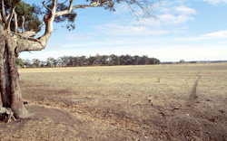 In the distance a remnant stand of Eucalyptus viminalis and Eucalyptus radiata on the sand ridge surrounding a former swamp. This swamp is now a broad alluvial plain that drains into Lal Lal Reservoir |
0.03% of CMA region This unit consists of a sandy ridge that has developed on the edge of a large swamp at Lal Lal. The exact genesis and reasons for existence of this sandy ridge are not entirely understood as firstly the ridge resembles a lunette in nature, yet lies on the opposite side to which it should given the prevailing wind direction, and secondly the coarse sandy nature of this ridge is confusing. As a sand ridge associated with swamps of the Western Uplands, there is a rich diversity of vegetation classes that coincide with the swamp plains. These vegetation classes include Aquatic Herbland/Plains Sedgy Wetland Mosaic, Grassy Woodland, Plains Sedgy Wetland with the dominant species being Eucalyptus radiata and E. viminalis. The sandy nature of these soils resulting in low fertility and water holding capacity has discouraged further clearing. Soils are primarily deep uniform sands. |  |
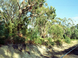 Cutting through the lakeside sand ridge north of Lal Lal |  |
| 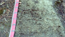 Sand profiles formed on top of Ordovician sediments are extremely leached and pale |

Component | 1 |
Proportion of soil-landform unit | 100% |
| CLIMATE Rainfall (mm) | Annual: 760 |
| Temperature (oC) | Minimum 7, Maximum 17 |
| Precipitation less than potential evapotranspiration | November-March |
| GEOLOGY Age and lithology | |
| Geomorphology | |
| LANDUSE | Uncleared: Nature conservation; water supply Cleared: Beef cattle and sheep grazing; cropping; residential development; soil stripping |
| TOPOGRAPHY Landscape | Gently undulating extremely low ridge |
| Elevation range (m) | 420-478 |
| Local relief (m) | 1-2 |
| Drainage pattern | - |
| Drainage density (km/km2) | 2.1 |
| Landform | Lakeside sand ridges |
| Landform element | |
| Slope and range (%) | 2-3 |
| Slope shape | Convex |
| NATIVE VEGETATION Ecological Vegetation Class | Aquatic Herbland/Plains Sedgy Wetland Mosaic (23.9%), Grassy Woodland (1.8%), Plains Sedgy Wetland (0.8%) |
| Dominant species | E. viminalis, E. radiata |
| SOIL Parent material | Unconsolidated sand |
| Description (Corangamite Soil Group) | Yellow or grey sand soils (11) |
| Soil type sites | |
| Surface texture | Sand |
| Permeability | High |
| Depth (m) | 2 |
| LAND CHARACTERISTICS, POTENTIAL AND LIMITATIONS | Soil tend to have a low water and nutrient holding capacity, therefore leading to fertility decline. |
© State of Victoria (Agriculture Victoria) 1996 - .

This work, Victorian Resources Online, is licensed under a Creative Commons Attribution 4.0 licence. You are free to re-use the work under that licence, on the condition that you credit the State of Victoria (Agriculture Victoria) as author, indicate if changes were made and comply with the other licence terms.
The licence does not apply to ‘branding’ or some ‘images or photographs’ that may be owned by third parties. We ask you to seek prior approval to use images using the VRO feedback form. Access to higher quality images can also be provided on request.
This page was last updated on .