
Soil/Landform Unit 25
Landform Unit Description
Page top
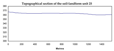
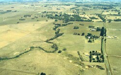 Gentle plains neighbouring the steeply dissected Moorabool River east branch north of Morrisons |
0.02% of CMA region The gently undulating plains in the Myrniong and Morrisons area are derived from Quaternary volcanics. Vegetation classes include Plains Grassy Woodland and Plains Grassland. Eucalyptus ovata is prevalent over much of the low relief landscape elements where soils are poorly drained. The weathered basalt has reasonable inherent fertility levels and a moderate water holding capacity. Soils include acidic and neutral mottled black texture contrast soils. There are minor occurrences of acidic mottled brown, grey or yellow and mottled brown texture contrast soils, and neutral shallow grey clays with a few surface stones. There are areas of extensive gilgai microrelief where the soils are acidic mottled black or neutral mottled brown, grey or yellow texture contrast soils. Sheet and rill erosion is associated with major rainfall events while gully erosion and leaching of salts also occur lower in the topography. |  |
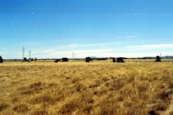 The main land use of these plains is grazing for fat lamb production |  |
|
Component | 1 | 2 | 3 | 4 |
Proportion of soil-landform unit | 70% | 2% | 15% | 13% |
| CLIMATE Rainfall (mm) | Annual: 670 | |||
| Temperature (oC) | Minimum 7, Maximum 18 | |||
| Precipitation less than potential evapotranspiration | October-March | |||
| GEOLOGY Age and lithology | Ordovician marine shale and sandstone, Neogene fluvio-marine sand, minor clay, sand and gravel | |||
| Geomorphology | ||||
| LANDUSE | Uncleared: Nature conservation, water supply Cleared: Sheep and beef cattle grazing; cropping (cereal) | |||
| TOPOGRAPHY Landscape | Gently undulating plains | |||
| Elevation range (m) | 323-375 | |||
| Local relief (m) | 3 | |||
| Drainage pattern | Dendritic | |||
| Drainage density (km/km2) | 1.4 | |||
| Landform | Undulating plain | Flat plain | Drainage lines | |
| Landform element | Well drained non-sandy areas | Patches of deep sandy soil | Poorly drained non-sandy areas | Low lying areas |
| Slope and range (%) | 2 (1-3) | 2 (1-3) | 0 (-02) | 1 (1-3) |
| Slope shape | Convex | Convex | Flat | Concave |
| NATIVE VEGETATION Ecological Vegetation Class | Plains Grassy Woodland (2.6%), Plains Grassland (0.8%) | |||
| Dominant species | Callitris columellaris, E. viminalis, E. obliqua, E. radiata, E. rubida, E. pauciflora | Pteridium esculentum, E. viminalis | E. ovata | E. ovata |
| SOIL Parent material | Unconsolidated gravel, sand and clay | Unconoslidated sand | Unconsolidated gravel, sand and clay | Unconsolidated gravel, sand and clay |
| Description (Corangamite Soil Group) | Red mottled brown, grey or yellow texture contrast soil, fine structure (15) | Brown, grey or yellow sand soil, uniform texture (6) | Brown, grey or yellow sodic texture contrast soil, coarse structure (14) | |
| Soil type sites | ||||
| Surface texture | Sandy clay loam to loamy sand | Sand | Clay loam | Clay loam, sandy clay loam |
| Permeability | Moderate | High | Low | Moderate |
| Depth (m) | 2 | 2 | 2 | 2 |
| LAND CHARACTERISTICS, POTENTIAL AND LIMITATIONS | Harsetting surface and low permeability leads to overland flow. This flow often creates sheet and rill erosion with major rainfall events. Gully erosion and leaching of salts also occur. | Soils have low water holding capacity and low nutrient holding capacity. Soils experience leaching and soil fertility decline. | Hardsetting surfaces and low permeability leads to overland flow. This flow often creates sheet and rill erosion with major rainfall events. Gully erosion and leaching of salts also occur. Surface compaction can benefit from controlled traffic. | Hardsetting surfaces and low permeability leads to overland flow. This flow often creates sheet and rill erosion with major rainfall events. Gully erosion and leaching of salts occur. |
© State of Victoria (Agriculture Victoria) 1996 - .

This work, Victorian Resources Online, is licensed under a Creative Commons Attribution 4.0 licence. You are free to re-use the work under that licence, on the condition that you credit the State of Victoria (Agriculture Victoria) as author, indicate if changes were made and comply with the other licence terms.
The licence does not apply to ‘branding’ or some ‘images or photographs’ that may be owned by third parties. We ask you to seek prior approval to use images using the VRO feedback form. Access to higher quality images can also be provided on request.
This page was last updated on .