
Soil/Landform Unit 203
Landform Unit Description
Page top
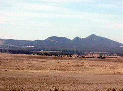
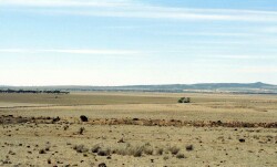
 The residual steep granitic hills of the You Yangs is well defined in the relatively planar surface of the Western Plains |
0.05% of CMA region The You Yangs are very steep hills almost entirely composed of granitic bedrock on the eastern boundary of the Corangamite catchment. The very steep hills are characterised by areas of prominent rock outcrop and gentler rock-free lower slopes. Within the Western Plains, these granitic hills are characterised by deep uniform sands on the upper slopes and acidic mottled yellow duplex soils on the lower slopes. Remnant vegetation includes Hills Herb-rich Woodland and Granitic Hills Woodland. Land use is restricted to grazing on native or introduced pastures due to the steepness and soil qualities such as low available water holding capacity and ready leaching of nutrients. The sand surfaces are prone to sheet erosion by water and wind. The permeable nature of these soils combined with steep slopes may provide a potential for landslips. Gully erosion occurs to a minor extent and can be difficult to control due to the steepness and inaccessibility of the drainage depressions. |  |
 Steep slopes and low water holding capacity of soils has restricted the land use mainly to grazing, nature walking and sport and recreation | 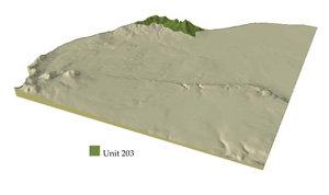 |
 |  Lower colluvial slopes of Unit 16 surround the You Yangs |
Component | 1 | 2 | 3 | 4 |
Proportion of soil-landform unit | 10% | 20% | 30% | 40% |
| CLIMATE Rainfall (mm) | Annual: 530 | |||
| Temperature (oC) | Minimum 9, Maximum 19 | |||
| Precipitation less than potential evapotranspiration | October–April | |||
| GEOLOGY Age and lithology | ||||
| Geomorphology | ||||
| LANDUSE | Uncleared: Nature conservation; sport and recreation; water supply Cleared: Sheep and cattle grazing; sand and granite extraction; severely disturbed | |||
| TOPOGRAPHY Landscape | Very steep hills of the You Yangs | |||
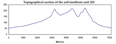
| Elevation range (m) | 52–331 | |||
| Local relief (m) | 170 | |||
| Drainage pattern | Dendritic | |||
| Drainage density (km/km2) | 1.1 | |||
| Landform | Very steep hills | |||
| Landform element | Crest and rock outcrops | Steep upper slope | Mid slope | Lower slope |
| Slope and range (%) | 5 (1–12) | 20 (10–40) | 10 (5–20) | 6 (3–15) |
| Slope shape | Convex | Convex | Concave | Straight |
| NATIVE VEGETATION Ecological Vegetation Class | Hills Herb-rich Woodland (7.9%), Granitic Hills Woodland (7.7%) | |||
| SOIL Parent material | In situ granite | In situ granite | In situ granite | In situ granite and colluvium |
| Description (Corangamite Soil Group) | Shallow and deep sand soils (4) | Deep sand soils (4) | Acidic mottled yellow texture contrast soils (3) | Acidic mottled yellow texture contrast soils (2) |
| Soil type sites | ||||
| Surface texture | Loamy sand | Loamy sand | Coarse sandy clay loam | Coarse sandy clay loam |
| Permeability | Very high | High | High to moderate | moderate |
| Depth (m) | < 1 | < 1 | < 1.5 | <2 |
| LAND CHARACTERISTICS, POTENTIAL AND LIMITATIONS | Rocky, sandy with low water holding capacity and nutrient holding capacity in surface and (bleached) subsurface soil. Generally hardsetting, occasionally loose. Rapid site drainage. Susceptibility to nutrient decline, sheet and rill erosion. | Some rock, sandy with low water holding capacity and nutrient holding capacity in surface and (bleached) subsurface soil. Generally hardsetting, occasionally loose. Very rapid site drainage. Susceptibility to nutrient decline, sheet and rill erosion, possibly gully erosion. | Some stone, coarse sand component. Texture contrast, low water holding capacity and nutrient holding capacity in surface and (bleached) subsurface soil, high in subsoil. Generally hardsetting. Rapid site drainage. Susceptibility to nutrient decline, sheet and rill erosion, possibly gully erosion. | Coarse sand component. Texture contrast, low water holding capacity and nutrient holding capacity in surface and (bleached) subsurface soil, high in subsoil. Generally hardsetting. Moderately rapid site drainage. Susceptibility to nutrient decline, sheet and rill erosion, possibly gully erosion. |
© State of Victoria (Agriculture Victoria) 1996 - .

This work, Victorian Resources Online, is licensed under a Creative Commons Attribution 4.0 licence. You are free to re-use the work under that licence, on the condition that you credit the State of Victoria (Agriculture Victoria) as author, indicate if changes were made and comply with the other licence terms.
The licence does not apply to ‘branding’ or some ‘images or photographs’ that may be owned by third parties. We ask you to seek prior approval to use images using the VRO feedback form. Access to higher quality images can also be provided on request.
This page was last updated on .