
Soil/Landform Unit 185
Landform Unit Description
Page top
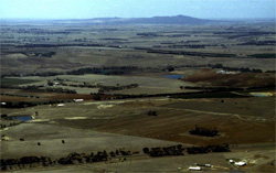 Level plains of Lara in the foreground of plains and rises leading to the You Yangs. This area is currently undergoing major land use change as the urban spread of Geelong further expands across this landscape |
0.34% of CMA region The near-level plains around Lara represent one of the driest areas in the Corangamite region. With an average annual rainfall of 490 mm and relatively high average yearly temperatures (minimum of 10o C and maximum of 20o C), land use may be somewhat limited with respect to higher rainfall regions of the catchment. Grazing and subdivision for residential and industrial development are the major land use practices of these plains. The geology comprises Recent clays, sand and gravel with minor Quaternary basalt found in the east. Topographically low (<40 m), this landscape has been vulnerable to marine inundations previously in geologic time. This is reflected in the abundance and occurrence of carbonate fragments at the surface of cultivated land. Native vegetation communities include Plains Grassy Woodland and Creekline Grassy Woodland. The sedimentary plain has black and red mottled texture contrast soils, with cracking clays found in lower depressions and sinks. Soils are prone to compaction and erosion due to the sodic nature of subsoils. |  |
 Red texture contrast soils with prominent carbonate fragments. Most likely these fragments have been brought to the surface via cultivation | 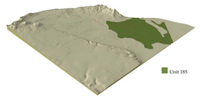 |
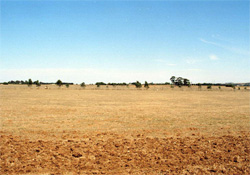
 | 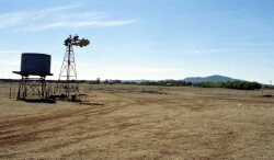 Level plains looking towards the You Yangs |
Component | 1 | 2 | 3 |
Proportion of soil-landform unit | 85% | 9% | 6% |
| CLIMATE Rainfall (mm) | Annual: 490 | ||
| Temperature (oC) | Minimum 10, Maximum 20 | ||
| Precipitation less than potential evapotranspiration | September–April | ||
| GEOLOGY Age and lithology | Recent clay, sand and gravel and minor Quaternary basalt | ||
| Geomorphology | |||
| LANDUSE | Uncleared: Nature conservation Cleared: Residential development, sheep and cattle grazing | ||
| TOPOGRAPHY Landscape | Level plain | ||
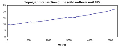
| Elevation range (m) | 8–40 | ||
| Local relief (m) | 13 | ||
| Drainage pattern | Dendritic | ||
| Drainage density (km/km2) | 1.1 | ||
| Landform | Plains | Drainage lines and depressions | |
| Landform element | Plain | Drainage line/stream channel | Depression |
| Slope and range (%) | 0 (0–1) | 2 (1–3) | 1 (0–1) |
| Slope shape | Linear | Concave | Concave |
| NATIVE VEGETATION Ecological Vegetation Class | Plains Grassy Woodland (1.6%), Creekline Grassy Woodland (0.7%) | ||
| SOIL Parent material | Colluvium and alluvium: clay, silt and sand | Colluvium and alluvium: clay, silt and sand | Colluvium and alluvium: clay, silt and sand |
| Description (Corangamite Soil Group) | Alkaline mottled black texture contrast soils (14) | ||
| Soil type sites | SW99, SW93, SW102 | ||
| Surface texture | Fine sandy clay loam | Fine sandy clay loam, light clay | Fine sandy clay loam, light clay |
| Permeability | Low | Low | Very low |
| Depth (m) | <2 | >2 | >2 |
| LAND CHARACTERISTICS, POTENTIAL AND LIMITATIONS | Texture contrast, moderate waterholding capacity and nutrient holding capacity in surface soil. Strongly sodic clay subsoil. Poor to moderate site drainage reflected in waterlogging and mottling. High organic matter may alleviate compaction and waterlogging susceptibility in surface soil. Carbonate present at surface and also in subsoil. | Texture contrast, moderate waterholding capacity and nutrient holding capacity in surface soil. Strongly sodic clay subsoil. Poor to moderate site drainage drainage reflected in waterlogging and mottling. High organic matter may alleviate compaction and waterlogging susceptibility in surface soil. Carbonate present at surface and also in subsoil. | Texture contrast, moderate waterholding capacity and nutrient holding capacity in surface soil. Heavier clay soils are prone to cracking. Strongly sodic clay subsoil. Poor to moderate site drainage reflected in mottling and low-lying areas of landscape. High organic matter may alleviate compaction and waterlogging susceptibility in surface soil. |
© State of Victoria (Agriculture Victoria) 1996 - .

This work, Victorian Resources Online, is licensed under a Creative Commons Attribution 4.0 licence. You are free to re-use the work under that licence, on the condition that you credit the State of Victoria (Agriculture Victoria) as author, indicate if changes were made and comply with the other licence terms.
The licence does not apply to ‘branding’ or some ‘images or photographs’ that may be owned by third parties. We ask you to seek prior approval to use images using the VRO feedback form. Access to higher quality images can also be provided on request.
This page was last updated on .