
Soil/Landform Unit 176
Landform Unit Description
Page top
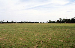 Undulating slopes are a mixture of residual sands overlying friable loams of limestone and marl. These sands are variable in occurrence and depth across this unit |
0.64% of CMA region These gently undulating plains are part of the sedimentary Western Plains. This single unit is found in the south-west of the catchment, west of the Curdies River in the Nirranda, Brucknell area and is generally formed on Neogene sandy sediments and where dissection has occurred, exposed Neogene marl and limestone. The dissection of the plains is sub-parallel, draining east into the Curdies River. The unit is characterised by hillslopes, plains and depressions with the remnant vegetation including Lowland Forest, Damp Heathland/Damp Heathy Woodland Mosaic and Herb-rich Foothill Forest. The soils are acidic brown texture contrast soils (Chromosols and Kurosols) on the plains and grey cracking clays (Vertosols) in the depressions. These moderately drained soils have low nutrient levels in the lighter topsoils due to the higher rainfall of this area. Land use is grazing, generally for dairying with some minor associated cropping. Some mass movement may occur at geological or pedalogical boundaries (sandy upper soil material over marl or limestone), with sandy material moving downslope. | 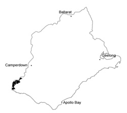 |
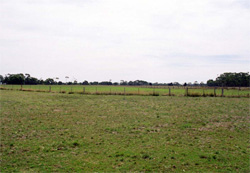 The undulating plains are mainly used for grazing by dairy and cropping (horticulture and fodder) | 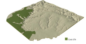 |
 |
Component | 1 | 2 | 3 |
Proportion of soil-landform unit | 20% | 60% | 20% |
| CLIMATE Rainfall (mm) | Annual: 880 | ||
| Temperature (oC) | Minimum 10, Maximum 19 | ||
| Precipitation less than potential evapotranspiration | November–March | ||
| GEOLOGY Age and lithology | Neogene fluvial-marine clay, sand and gravel; minor marl, calcarenite | ||
| Geomorphology | |||
| LANDUSE | Uncleared areas: Hardwood forestry for sawlogs, posts and poles; softwoood plantations; water supply; nature conservation Cleared areas: Dairy farming; beef cattle and sheep grazing; cropping (horticulture); softwood plantations | ||
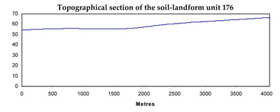
| TOPOGRAPHY Landscape | Gently undulating plains | ||
| Elevation range (m) | 6–128 | ||
| Local relief (m) | 10 | ||
| Drainage pattern | Dendritic | ||
| Drainage density (km/km2) | 1.1 | ||
| Landform | Gently undulating plains | Drainage depressions | |
| Landform element | Dissected hillslopes | Gently undulating plains | Fine drainage pattern/pediment rivulets |
| Slope and range (%) | 3 (1–7) | 1 (0–3) | 1 (0–2) |
| Slope shape | Convex | Straight | Concave |
| NATIVE VEGETATION Ecological Vegetation Class | Lowland Forest (2.6%), Damp Heathland/Damp Heathy Woodland Mosaic (1.5%), Herb-rich Foothill Forest (0.9%) | ||
| SOIL Parent material | Clay, silt sand and marl | Clay, silt and sand | Clay, silt sand and marl |
| Description (Corangamite Soil Group) | Mottled brown, grey and yellow texture contrast soils (13) | Alkaline grey cracking clays (31) | |
| Soil type sites | |||
| Surface texture | Fine sandy loam | Fine sandy loam | Medium clay |
| Permeability | Moderate | Moderate to low | Very low |
| Depth (m) | <2 | <2 | >2 |
| LAND CHARACTERISTICS, POTENTIAL AND LIMITATIONS | Texture contrast, mottled with swelling clay subsoils, but light topsoils. Moderate to poor permeability, good site drainage. Low nutrient holding capacity in subsurface soil, higher in surface soil (organic matter) and subsoil (clay, some calcareous material). | Texture contrast, mottled with swelling clay subsoils, but light topsoils. Moderate to poor permeability and site drainage. Low nutrient holding capacity in subsurface soil, higher in surface soil (organic matter) and subsoil (clay). | Swelling clay soil may be strongly structured. Very poor site drainage, susceptible to waterlogging and compaction. High nutrient holding capacity, generally sodic. |
© State of Victoria (Agriculture Victoria) 1996 - .

This work, Victorian Resources Online, is licensed under a Creative Commons Attribution 4.0 licence. You are free to re-use the work under that licence, on the condition that you credit the State of Victoria (Agriculture Victoria) as author, indicate if changes were made and comply with the other licence terms.
The licence does not apply to ‘branding’ or some ‘images or photographs’ that may be owned by third parties. We ask you to seek prior approval to use images using the VRO feedback form. Access to higher quality images can also be provided on request.
This page was last updated on .