
Soil/Landform Unit 164
Landform Unit Description
Page top
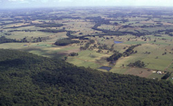 Limestone scarps and slopes at Scotts Creek |
0.59% of CMA region Rolling dissected low hills of the western Heytesbury region are derived from Miocene marine clay, marl and limestone. These rolling low hills occur from north of Scotts Creek through to Port Campbell. Steep dissection of the landscape has led to steep slopes and scarps with noticeable terracing prominent from lower broad drainage depressions and lines. This unit is a neighbour to the dissected rolling hills without cappings of soil-landform unit 165. Soils on these Miocene sediments are typically black, grey and yellow earths, with heavier earths found lower in the landscape. Limestone is often present at depth in the soil profile. Soils on these sediments are significantly more fertile than the sandy soils formed on the Neogene sediments of very few crests in this unit. Nearly all native vegetation has been cleared as part of the soldier settlement. Dairy farming is the main land use. Subsoils are dispersible and gully erosion has occurred along some drainage lines. Landslip and slumping is much less severe than of that in neighbouring soil-landform units 165 and 160. Drainage lines and lower slopes remain waterlogged for most of the year and can be prone to soil compaction (pugging) by stock. | 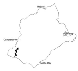 |
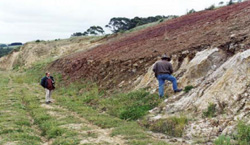
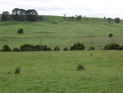 Long straight slopes and scarps of the Port Campbell Limestone at Scotts Creek | 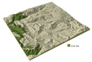 |
 |  Quaternary basalt overlying Miocene Port Campbell limestone in the valley of the Curdies River |
Component | 1 | 2 | 3 | 4 | 5 |
Proportion of soil-landform unit | 17% | 5% | 45% | 25% | 8% |
| CLIMATE Rainfall (mm) | Annual: 900-1000, lowest January (40), highest August (120) | ||||
| Temperature (oC) | Annual: 14, lowest July (9), highest February (18) | ||||
| Precipitation less than potential evapotranspiration | November-March | ||||
| GEOLOGY Age and lithology | Miocene marine marl and marine calcarenite | ||||
| Geomorphology | |||||
| LANDUSE | Cleared areas: Dairy cattle; grazing beef cattle; sheep Minor uncleared areas: Nature conservation; includes forests at Timboon and Scotts Creek | ||||
| TOPOGRAPHY Landscape | Roling dissected low hills with remnant plain cappings | ||||
| Elevation range (m) | 3-167 | ||||
| Local relief (m) | 60 | ||||
| Drainage pattern | Parallel | ||||
| Drainage density (km/km2) | 2.6 | ||||
| Landform | Ridges | Fault scarps | Hillslops | Drainage lines | |
| Landform element | Upper slope and crest | - | Mid slope and crest | Lower slope | - |
| Slope and range (%) | 5 (2-9) | 33 | 11 (4-21) | 4 (1-7) | 0 (0-1) |
| Slope shape | Linear | Linear | Convex | Concave | LInear |
| NATIVE VEGETATION Ecological Vegetation Class | Open forest | Woodlnad | Woodland | Woodland | Closed scrub |
| Dominant species | E. obliqua, E. ovata, E. aromaphloia | E. viminalis, A. melanoxylon | E. ovata, E. radiata | E. obliqua, E. ovata | M. squarrosa, L. lanigerum |
| SOIL Parent material | In situe marl and limeston | In situ marl and limestone | Clay with in situ marl and limestone | Clay and sand | Plant remnants, alluvial sand and clay |
| Description (Corangamite Soil Group) | Black calcareious gradational soils (22) | Mottled brown, yellow and grey gradational soils (22) | Grey gradational soils (22) | ||
| Soil type sites | SW52, CLRA10, MM413 | OTR733 | |||
| Surface texture | Clay | Clay | Loam | Sandy loam | Silty loam |
| Permeability | Moderate | Moderate | Low | Moderate | Low |
| Depth (m) | >2 | >2 | 1.7 | >2 | >2 |
| LAND CHARACTERISTICS, POTENTIAL AND LIMITATIONS | Highly dispersible soils of low permeability are prone to gully and sheet erosion. Low inherent ferility and leaching of permeable surfaces lead to nutrient decline. | Clay soils on steep slopes subject to periodic saturation are prone to landslips and sheet erosion. | Clay subsoils on steeper slopes subject to periodic saturation are pone to landslips, slumping of road batters and gully erosion. | Dispersible subsoils are prone to gully erosion. | Dispersible subsoil of low permeability receiving runoff from surrounding hills are prone to gully erosion, waterlogging and soil compaction. |
© State of Victoria (Agriculture Victoria) 1996 - .

This work, Victorian Resources Online, is licensed under a Creative Commons Attribution 4.0 licence. You are free to re-use the work under that licence, on the condition that you credit the State of Victoria (Agriculture Victoria) as author, indicate if changes were made and comply with the other licence terms.
The licence does not apply to ‘branding’ or some ‘images or photographs’ that may be owned by third parties. We ask you to seek prior approval to use images using the VRO feedback form. Access to higher quality images can also be provided on request.
This page was last updated on .