
OTR784
|
| OTR784 | 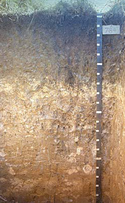 Sodic, Hypercalcic, Brown Dermosol | |
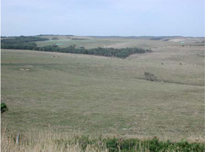
| Princetown | |||
| Hill | |||
| Neogene Gellibrand Marl | |||
| Hillcrest | |||
| 4% | |||
| South-south-westerly | |||
Horizon | Depth (cm) | Description | ||
A1 | 0–10 | Black (10YR2/1); light clay moderate very fine (3 mm) subangular blocky structure; gradual wavy boundary to: | ||
B21 | 10–42 | Dark yellowish brown (10YR4/4); heavy clay; moderate very fine (3 mm) subangular blocky structure; clay skin cutans; hard when dry; diffuse smooth boundary to: | ||
B22 | 42–60 | Dark yellowish brown (10YR5/4); heavy clay; strong very fine (3 mm) angular blocky structure; clay skin cutans; diffuse wavy boundary to: | ||
B2ca | 60–90 | Very pale brown (10YR7/4); medium clay; dominated by soft accumulations of calcium carbonate; moderate fine (6 mm) subangular blocky structure; clear wavy boundary to: | ||
C1 | 90–120 | Light grey (10YR7/1) with brownish yellow (10YR6/6) mottles; medium clay; weak very coarse (50 mm) subangular blocky structure; calcium carbonate concretions common; gradual wavy boundary to: | ||
C2 | 120–165 | Light yellowish brown (10YR6/4) with light grey (10YR7/1) mottles; heavy clay; weak very coarse (50 mm) angular blocky structure; some calcium carbonate concretions; clear smooth boundary to: | ||
C3 | 165–180 | Very pale brown (10YR7/3) with brownish yellow (10YR6/8) and grey (10YR6/1) mottles; medium clay; apedal massive structure; soft nodules of lime and phosphate common; clear smooth boundary to: | ||
C4 | 180+ | Pale brown (10YR6/3) with yellow (10YR7/8) and grey (10YR6/1) mottles; medium clay; weak very coarse (80 mm) angular blocky structure; some calcium carbonate concretions. | ||
| Management considerations | ||||
| The B2 contains slickensided faces and organans. The gradational nature of these soils provides few physical limitations to water and gas movement through the profile. The agricultural potential of the soil is dependent however on any chemical or depth restrictions. With a shallow topsoil (generally 10cm or less) there is a reduced water holding capacity limiting root growth and increasing susceptibility to waterlogging. Alkaline subsoil horizons are associated with a high nutrient capacity but result in an imbalance in nutrient availability (may be restrictive to certain plant species (eg. potatoes). These soils are often associated with sodic and calcic soil properties. Calcium carbonate and phosphatic nodules (segregations, soft and hard) are indicative of alkaline subsoils. | ||||
Analytical data
Site OTR784 | Sample depth | pH | EC | NaCl | Ex Ca | Ex Mg | Ex K | Ex Na | Ex Al | Ex acidity | FC (-10kPa) | PWP (-150kPa) | KS | FS | Z | C | |
Horizon | cm | H2O | CaCl2 | dS/m | % | cmolc/kg | cmolc/kg | cmolc/kg | cmolc/kg | mg/kg | cmolc/kg | % | % | % | % | % | % |
A1 | 0-10 | 7.0 | N/R | 0.160 | 0.012 | 15.2 | 4.5 | 1.2 | 0.4 | N/R | N/R | N/R | N/R | 1 | 28 | 30 | 28 |
B21 | 10-20 | 6.7 | N/R | 0.073 | 0.009 | N/R | N/R | N/R | N/R | N/R | N/R | N/R | N/R | N/R | N/R | N/R | N/R |
B21 | 20-30 | 6.6 | N/R | 0.060 | 0.009 | N/R | N/R | N/R | N/R | N/R | N/R | N/R | N/R | N/R | N/R | N/R | N/R |
B21 | 30-42 | 6.8 | N/R | 0.062 | 0.010 | 13.5 | 4.8 | 0.7 | 0.6 | N/R | N/R | N/R | N/R | 1 | 22 | 19 | 53 |
B22 | 42-60 | 7.3 | N/R | 0.083 | 0.013 | 20.0 | 4.8 | 0.6 | 0.7 | N/R | N/R | N/R | N/R | 0.4 | 16 | 16 | 61 |
B2ca | 60-90 | 8.6 | N/R | 0.130 | 0.014 | 10.3 | 1.7 | 0.2 | 0.3 | N/R | N/R | N/R | N/R | 6 | 19 | 37 | 25 |
C1 | 90-120 | 8.7 | N/R | 0.180 | 0.020 | 14.9 | 3.3 | 0.3 | 0.8 | N/R | N/R | N/R | N/R | 10 | 18 | 17 | 42 |
C2 | 120-150 | 8.8 | N/R | 0.340 | 0.036 | 15.2 | 5.9 | 0.4 | 2.3 | N/R | N/R | N/R | N/R | 2 | 15 | 16 | 54 |
C3 | 165-180 | 9.1 | N/R | 0.240 | 0.022 | 5.5 | 2.8 | 0.1 | 1.1 | N/R | N/R | N/R | N/R | 10 | 26 | 30 | 20 |
C4 | 195-210 | 8.9 | N/R | 0.410 | 0.037 | 10.9 | 8.6 | 0.4 | 3.7 | N/R | N/R | N/R | N/R | 1 | 18 | 14 | 55 |
© State of Victoria (Agriculture Victoria) 1996 - .

This work, Victorian Resources Online, is licensed under a Creative Commons Attribution 4.0 licence. You are free to re-use the work under that licence, on the condition that you credit the State of Victoria (Agriculture Victoria) as author, indicate if changes were made and comply with the other licence terms.
The licence does not apply to ‘branding’ or some ‘images or photographs’ that may be owned by third parties. We ask you to seek prior approval to use images using the VRO feedback form. Access to higher quality images can also be provided on request.
This page was last updated on .