
Soil/Landform Unit 162
Landform Unit Description
Page top
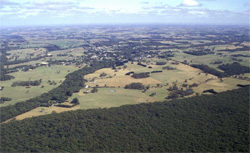 The cleared land denotes the undulating crests and slopes of this unit while the vegetation marks the steeply dissected rivers and streams around Timboon |
1.01% of CMA region The undulating low hills in the Timboon West area are characterised by broad crests and slopes that abruptly change to scarps and steep slopes lining the streams and rivers of the lower Heytesbury area. The sedimentary dissected plains are a prominent and unique landform of the Western Plains. The area is generally formed on Neogene marl and limestone where dissection of later deposited Neogene sandy sediments has exposed the underlying sedimentary strata of marl and limestone. Soils of the low hills are typically acidic friable brown gradational soils (Dermosols). These soils are free draining but have low nutrient levels in the topsoil from leaching due to the higher rainfall of this area. Sandy cappings are also common with uniform sands (Podosols). Remnant vegetation includes stringybarks, peppermints and heathy vegetation as part of the vegetation classes Lowland Forest, Damp Heath Scrub and Herb-rich Foothill Forest. This unit is quite fragmented and dissected by streams and rivers. Land use is mainly grazing, generally for dairying, with some minor associated cropping. Some mass movement may occur at geological boundaries (capping material over marl or limestone), with sandy material moved downslope. | 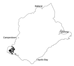 |
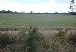 Many of the undulating plains and cappings have thin veneers of sands of the Hanson Plain Sand | 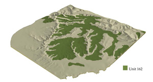 |
 | 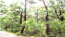 Remnant vegetation stand near Timboon |
Component | 1 | 2 | 3 | 4 |
Proportion of soil-landform unit | 20% | 35% | 40% | 5% |
| CLIMATE Rainfall (mm) | Annual: 900 | |||
| Temperature (oC) | Minimum 10, Maximum 18 | |||
| Precipitation less than potential evapotranspiration | November-March | |||
| GEOLOGY Age and lithology | Neogene fluvial-marine marl, silt, gravel and limestone | |||
| Geomorphology | ||||
| LANDUSE | Uncleared areas: Hardwood forestry for sawlogs, posts and poles; softwood plantations; water supply; nature conservation Cleared areas: Dairy farming; sheep and beef cattle grazing; softwood plantations; water supply | |||
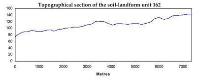
| TOPOGRAPHY Landscape | Undulating low hills | |||
| Elevation range (m) | 5-156 | |||
| Local relief (m) | 40 | |||
| Drainage pattern | Dendritic | |||
| Drainage density (km/km2) | 0.8 | |||
| Landform | Hills | Drainage lines | ||
| Landform element | Broad crests | Upper slope | Lower slope | |
| Slope and range (%) | 4 (1-7) | 12 (5-25) | 5 (2-10) | 0 (0-1) |
| Slope shape | Convex | Convex | Concave | Linear |
| NATIVE VEGETATION Ecological Vegetation Class | Lowand Forest (4.2%), Damp Heath Scrub (2.7%), Herb-rich Foothill Forest (1.5%) | |||
| SOIL Parent material | Unconsolidated sand, limestone | Unconsolidated sand, limestone | Unconsolidated sand, limestone | Unconsolidated sand, limestone |
| Description (Corangamite Soil Group) | Acidic, friable brown gradational soils (22) | Acidic, friable brown gradational soils (22) | Acidic, friable brown gradational soils (22) | Acidic, friable black and brown gradational soils (34) |
| Soil type sites | ||||
| Surface texture | Clay loam, sandy clay loam | Clay loam | Clay loam | Clay loam |
| Permeability | Moderate to high | Moderate to high | Moderate | Moderate |
| Depth (m) | <2 | <2 | >2 | >2 |
| LAND CHARACTERISTICS, POTENTIAL AND LIMITATIONS | Friable, generally modeately deep to deep soils. Often strongly acidic, moderate nutrient holding capacity. Moderately weel to poorly drained drainage. Varialbe surface soil sand content, but high organic matter. | Friable, generally moderately deep to deep soils. Often strongly acidic, moderate nutrient holding capacity. Moderately well to poorly drained drainage. Variable surface soil sand content, but high organic matter. | Friable, generally deep to very deep soils. Often strongly acidic, moderate nutrient holding capacity. Moderately well to poorly drained drainage. Variable surface soil and content, but high organic matter. | Friable, generaly deep to very deep soils. Often strongly acidic, moderate nutrient holding capacity. Poor site drainage. Variable surface soil sand content, but high organic matter. |
© State of Victoria (Agriculture Victoria) 1996 - .

This work, Victorian Resources Online, is licensed under a Creative Commons Attribution 4.0 licence. You are free to re-use the work under that licence, on the condition that you credit the State of Victoria (Agriculture Victoria) as author, indicate if changes were made and comply with the other licence terms.
The licence does not apply to ‘branding’ or some ‘images or photographs’ that may be owned by third parties. We ask you to seek prior approval to use images using the VRO feedback form. Access to higher quality images can also be provided on request.
This page was last updated on .