
Soil/Landform Unit 161
Landform Unit Description
Page top
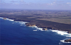 The Twelve Apostles and undulating coastal plains of the south-west coast |
0.83% of CMA region Undulating plains in the south-west of the Corangamite catchment are formed on Miocene limestone, marl and calcareous clay. The landscape is quite extensive, stretching along the coastline from Princetown to Peterborough. Some faulting has led to occasional steep scarps, but most slopes are gentle and straight, separated by broad drainage lines. The gradational soils on these calcareous sediments are heavier textured and significantly more fertile than soils formed on Neogene sediments in adjacent units. Free lime is often present at depth in the soil profile. Remnants of the native vegetation indicate that it was somewhat stunted, possibly as a result of the proximity to the coast. Remnant vegetation includes stringybarks, peppermints and heathy vegetation as part of the vegetation classes Coastal Headland Scrub, Damp Heath Scrub, Shrubby Foothill Forest and Herb-rich Foothill Forest. Dairy farming is the main land use, although some of the earlier established areas close to the coast are used for sheep and beef cattle grazing. Subsoils are dispersible and gully erosion has occurred along some drainage lines. Landslip and slumping of road batters cause problems with road construction and access on the more undulating areas. Drainage lines remain waterlogged for most of the year and are prone to soil compaction by stock. | 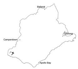 |
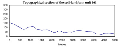
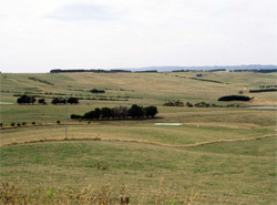 Long straight slopes with broad drainage lines typify this | 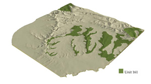 |
 | 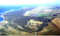 Undulating plains west of Port Campbell |
Component | 1 | 2 | 3 | 4 | 5 |
Proportion of soil-landform unit | 4% | 65% | 20% | 8% | 3% |
| CLIMATE Rainfall (mm) | Annual: 900-1000, lowest January (40), highest August (120) | ||||
| Temperature (oC) | Annual: 14, lowest July (9), highest February (18) | ||||
| Seasonal growth limitations | Temperature: less than 10oC (av.) June-August Precipitation: less than potential evapotranspiration November-March | ||||
| GEOLOGY Age and lithology | Miocene marine clay, marl and limestone in the lower reaches of the Gellibrand River catchment | ||||
| Geomorphology | |||||
| LANDUSE | Cleared areas: Grazing beef cattle; dairy cattle; sheep Minor uncleared area: Nature conservation; including the rugged coastline of the Port Campbell National Park | ||||
| TOPOGRAPHY Landscape | Undulating plain with some fault scarps | ||||
| Elevation range (m) | 0-165 | ||||
| Local relief (m) | 45 | ||||
| Drainage pattern | Dendritic | ||||
| Drainage density (km/km2) | 2.9 | ||||
| Landform | Rise | Drainage lines | Fault scarp | ||
| Landform element | Upper slope and crest | Mid slope and crest | Lower slopes | - | - |
| Slope and range (%) | 5 (2-9) | 11 (4-21) | 4 (1-7) | 0 (0-1) | 33 |
| Slope shape | Linear | Convex | Concave | Linear | Linear |
| NATIVE VEGETATION Structure | Open forest | Woodland | Woodland | Closed scrub | Woodland |
| Dominant species | E. obliqua, E. ovata, E. aromaphloia | E. ovata, E. radiata | E. obliqua, E. ovata | Melaleuca squarrosa, Leptospermum lanigerum | E. viminalis, Acacia melanoxylon |
| SOIL Parent material | Clay and sand | In situ marl, limestone | Clay and sand | Plant remnants, alluvial sand and clay | In situ marl and limestone |
| Description (Corangamite Soil Group) | Brown texture contrast soils, coarse structure (21) | Mottled brown, yellow and grey gradational soils (22) | Grey gradational soils (22) | ||
| Soil type sites | OTR733, CLRA10 | - | |||
| Surface texture | Fine sandy loam | Loam | Sandy loam | Silty loam | Clay |
| Permeability | Very low | Low | Moderate | Low | Moderate |
| Depth (m) | >2 | 1.7 | >2 | >2 | >2 |
| LAND CHARACTERISTICS, POTENTIAL AND LIMITATIONS | Highly dispersible soils of low permeability are prone to gully and sheet erosion. Low inherent fertility and leaching of permeable surfaces lead to nutrient decline. | Clay subsoils on steeper slopes subject to periodic saturation are prone to landslips, slumping of road batters and gully erosion. | Dispersible subsoils are prone to gully erosion. | Dispersible subsoils of low permeable receiving runoff from surrounding hills are prone to gully erosion, waterlogging and soil compaction. | Clay soils on steep slopes subject to periodic saturation are prone to landslips an sheet erosion. |
© State of Victoria (Agriculture Victoria) 1996 - .

This work, Victorian Resources Online, is licensed under a Creative Commons Attribution 4.0 licence. You are free to re-use the work under that licence, on the condition that you credit the State of Victoria (Agriculture Victoria) as author, indicate if changes were made and comply with the other licence terms.
The licence does not apply to ‘branding’ or some ‘images or photographs’ that may be owned by third parties. We ask you to seek prior approval to use images using the VRO feedback form. Access to higher quality images can also be provided on request.
This page was last updated on .