
Soil/Landform Unit 128
Landform Unit Description
Page top
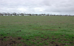 Gently undulating plain on granite to the east of Bannockburn |
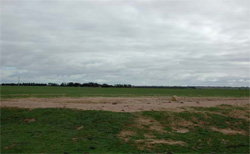
0.08% of CMA region The undulating granitic rises south of Anakie are part of the granitic landscapes within the dissected Western Plains. The gentle to undulating slopes graduate into prominent footslopes and drainage depressions. Remnant vegetation on the granite is sparse with the Grassy Woodland being the major vegetation class. The soils consist of mottled texture contrast soils with sodic medium to heavy clay subsoils. Land use is restricted to grazing and cropping due to the low available water holding capacity and ready leaching of nutrients from these soils. Gully erosion occurs to a minor extent with sheet and rill erosion. Salting can also be expressed at the surface as evidenced by the presence of spiny rush. |  |
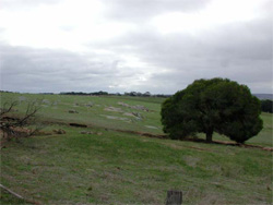 Granite boulders outcropping in the valley of the Moorabool River |  |
 |  The loose sandy topsoil of the granites is particularly prone to sheet and rill as well as gully and tunnel erosion. |
Component | 1 | 2 |
Proportion of soil-landform unit | 60% | 40% |
| CLIMATE Rainfall (mm) | Annual: 560 | |
| Temperature (oC) | Minimum 9, Maximum 19 | |
| Precipitation less than potential evapotranspiration | October-April | |
| GEOLOGY Age and lithology | ||
| Geomorphology | ||
| LANDUSE | Uncleared: Nature conservation Cleared: Sheep grazing; limited cropping (cereal) | |
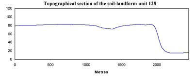
| TOPOGRAPHY Landscape | Undulating rises | |
| Elevation range (m) | 12-169 | |
| Local relief (m) | 35 | |
| Drainage pattern | Dendritic | |
| Drainage density (km/km2) | 1.0 | |
| Landform | Plains | Rises with tors on crest |
| Landform element | Lower slopes | Upper slopes |
| Slope and range (%) | 1-3 | 3-10 |
| Slope shape | Straight | Convex |
| NATIVE VEGETATION Ecological Vegetation Class | Grassy Woodland (4.1%) | |
| Dominant species | Eucalyptus leucoxylon | |
| SOIL Parent material | In situ weathered basalt | In situ weathered granite |
| Description (Corangamite Soil Group) | Shallow mottled brown texture contrast soils (1) | |
| Soil type sites | SW104, MM5102 | |
| Surface texture | Sandy loam | Sandy loam |
| Permeability | Moderate | Moderate |
| Depth (m) | 1.0-2.0 | 0.3-1.0 |
| LAND CHARACTERISTICS, POTENTIAL AND LIMITATIONS | Slope position and surface runoff may result in minor sheet erosion. | Slopes, hardsetting surfaces and overland flow may cause moderate sheet and rill erosion. |
© State of Victoria (Agriculture Victoria) 1996 - .

This work, Victorian Resources Online, is licensed under a Creative Commons Attribution 4.0 licence. You are free to re-use the work under that licence, on the condition that you credit the State of Victoria (Agriculture Victoria) as author, indicate if changes were made and comply with the other licence terms.
The licence does not apply to ‘branding’ or some ‘images or photographs’ that may be owned by third parties. We ask you to seek prior approval to use images using the VRO feedback form. Access to higher quality images can also be provided on request.
This page was last updated on .