
18.3 Landslip - Wild Dog Creek
This information has been developed from the publications:
|
| Location: | 18 - 322134. Junction of Wild Dog Creek Road and Rusty Road. | |
Access: | Wild Dog Creek Road. | |
Ownership: | Private land and Crown land (Road reserve). | |
Geomorphology: | This is a complex landslip involving movement of weathered Cretaceous Rocks. | |
Significance: | Local. The slip is a clear example of a mass movement process common on the steep cleared slopes in the Apollo Bay area. | |
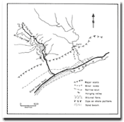 Outline of Wild Dog Creek. | 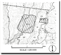 Map of Sites 18.2 and 18.3. |
© State of Victoria (Agriculture Victoria) 1996 - .

This work, Victorian Resources Online, is licensed under a Creative Commons Attribution 4.0 licence. You are free to re-use the work under that licence, on the condition that you credit the State of Victoria (Agriculture Victoria) as author, indicate if changes were made and comply with the other licence terms.
The licence does not apply to ‘branding’ or some ‘images or photographs’ that may be owned by third parties. We ask you to seek prior approval to use images using the VRO feedback form. Access to higher quality images can also be provided on request.
This page was last updated on .