
18.2 Barham River East Branch Ridge - Landslip Control
This information has been developed from the publications:
|
| Location: | 18-313137. Ridge between Wild Dog Creek and Barham River eight kilometres south of Apollo Bay. | |
Access: | Wild Dog Track. | |
Ownership: | Crown land (Reserved Forest). | |
Geology/Geomorphology: | The site is a forested ridge trending north-south and dividing the Wild Dog Creek and Barham River East Branch. Relief from the valley floor to ridge crest is approximately 150 metres. Outcrop is limited to the creeks but the trend of the ridge is probably determined by the strike of the Mesozoic sedimentary rocks of the Otway Group. It is proposed that the site be used as a control site for comparative studies of landslips and other mass movements with adjacent ridges of similar relief and geology. These adjacent sites show extensive mass movement forms, and this instability in part is due to a different land use history, e.g. Site 18.3. | |
Significance: | State. It is essential that sufficient reference sites be available to display the nature of land surfaces prior to European settlement in Australia, particularly in areas where adjacent slopes have been completely cleared of forest and used for grazing or agriculture. In this way, an assessment of the impact of settlement on slope stability, soils and run-off may be undertaken. | |
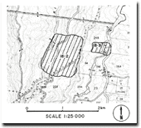 Map of Sites 18.2 and 18.3 |
© State of Victoria (Agriculture Victoria) 1996 - .

This work, Victorian Resources Online, is licensed under a Creative Commons Attribution 4.0 licence. You are free to re-use the work under that licence, on the condition that you credit the State of Victoria (Agriculture Victoria) as author, indicate if changes were made and comply with the other licence terms.
The licence does not apply to ‘branding’ or some ‘images or photographs’ that may be owned by third parties. We ask you to seek prior approval to use images using the VRO feedback form. Access to higher quality images can also be provided on request.
This page was last updated on .