
SW59
Location: Simpson.
Australian Soil Classification: Vertic, Sesquic, Semiaquic PODOSOL
Great Soil Group: podzol
General Landscape Description: Dissected Tertiary Sediments - Undulating Low Hills.
Sites description: Valley side, crest.
Geology: Veneer of Tertiary Hanson Plain Sand overlying Gellibrand Marl colluvium.
Land Use: Dairy cattle grazing.
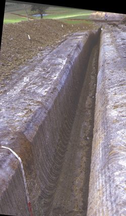
SW59 Landscape
Soil Profile Morphology:
Surface Soil
| A1 | 0-15 cm | Black (2.5Y2.5/1); sandy loam; pH 5.6; smooth change to: | 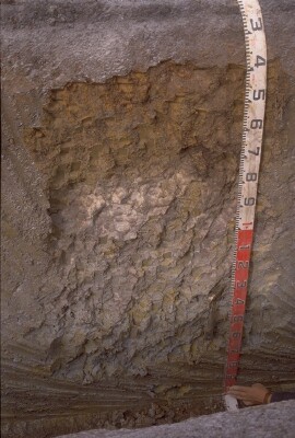 SW59 Profile. Note: Surface (A1) horizon has been stripped |
| A2 | 15-30 cm | Intermittent horizon; conspicuously bleached; clear and wavy change to: | |
| Subsoil | |||
| B21s | 15/30-60 cm | Mottled yellowish brown (10YR5/8) and very dark greyish brown (10YR3/2); sandy clay loam; weak very fine polyhedral structure; weak to firm consistence dry; weakly cemented 'coffee rock'; pH 5.3; gradual and wavy change to: | |
| B22g | 60-90 cm | Light olive brown (2.5Y5/4) with prominent yellow (10YR7/8) to yellowish brown (10YR5/8) mottles; sandy clay; very coarse polyhedral, parting to coarse blocky structure; whitish sand coatings on the larger ped faces; pH 5.5; clear and wavy change to: | |
| B23gss | 90+ cm | Light greenish grey (5GY7/1) with brownish yellow (10YR6/8) mottles; heavy clay; very coarse polyhedral, parting to coarse blocky structure; slickensides (>50 mm in size) present; pH 6.3. | |
Key Profile Features:
- Strong texture contrast between surface (A) horizons and subsoil (B21) horizon.
- Water logging in the subsoil.
pH | Salinity Rating | |||
Surface (A1 horizon) | Moderately Acid | Low | Non-Sodic | None |
Subsoil (B21 horizon) | Strongly Acid | Low | Non-Sodic | None |
Deeper Subsoil (at 90+ cm) | Slightly Acid | Low | - | - |
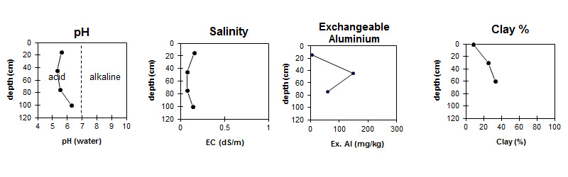
| The surface is moderately acid. The subsoil is strongly acid becoming slightly acid with depth. | The salinity rating is low throughout the profile. | Exchangeable Aluminium increases to very high levels in the subsoil. | The clay content increases slightly down the profile. |
Horizon | Horizon Depth (cm) | pH (water) | pH (CaCl2) | EC (dS/m) | Exchangeable Cations | |||
Ca | Mg | K | Na | |||||
meq/100g | ||||||||
A1 | 0-15 | 5.6 | 5 | 0.16 | * 5.8 | 0.87 | 0.26 | 0.33 |
| Sporadic A2 not sampled | ||||||||
B21 | 15/30-60 | 5.3 | 4.5 | 0.08 | 0.83 | 1 | 0.12 | 0.27 |
B22 | 60-90 | 5.5 | 4.6 | 0.08 | 1.2 | 2.8 | 0.14 | 0.41 |
B3 | 90+ | 6.3 | 5.2 | 0.14 | ||||
* High levels of Exchangeable Calcium could be due to liming.
Horizon | Horizon Depth (cm) | Oxidisable Organic Carbon % | Total Nitrogen % | Exchangeable Aluminium mg/kg | Exchangeable Acidity meq/100g | Field Capacity pF2.5 | Wilting Point pF4.2 | Coarse Sand (0.2-2.0 mm) | Fine Sand (0.02-0.2 mm) | Silt (0.002-0.02 mm) | Clay (<0.002 mm) |
A1 | 0-15 | 4.6 | 0.26 | <10 | 12 | 20 | 9 | 24 | 49 | 11 | 9 |
| Sporadic A2 not sampled | |||||||||||
B21 | 15/30-60 | 150 | 11 | 20 | 11 | 18 | 48 | 2 | 25 | ||
B22 | 60-90 | 61 | 5.7 | 22 | 12 | 18 | 44 | 4 | 33 | ||
B3 | 90+ | ||||||||||
Management Considerations:
Subsoil (B) Horizons
- Exchangeable aluminium levels are quite high in the strongly acid upper subsoil. This may restrict the growth of aluminium sensitive species.
- Contrast gleyed subsoil - sandy clay to heavy clay represents transition from overlying Hanson Plain Sand to underlying Gellibrand Marl.
Profile Described By: Mark Imhof and Richard MacEwan (March 1999)
© State of Victoria (Agriculture Victoria) 1996 - .

This work, Victorian Resources Online, is licensed under a Creative Commons Attribution 4.0 licence. You are free to re-use the work under that licence, on the condition that you credit the State of Victoria (Agriculture Victoria) as author, indicate if changes were made and comply with the other licence terms.
The licence does not apply to ‘branding’ or some ‘images or photographs’ that may be owned by third parties. We ask you to seek prior approval to use images using the VRO feedback form. Access to higher quality images can also be provided on request.
This page was last updated on .