
SW37
Location: Irrewillipe
Australian Soil Classification: Epiacidic, Epipedal, Black VERTOSOL
Map Unit: Map Unit 116 (Maher and Martin, 1987).
General Landscape Description: Level plain with Swamp Gum (E. ovata).
Site Description: Grazing paddock.
Geology: Quaternary sediments overlying Tertiary - Moorabool Viaduct Formation.
 SW37 Landscape |
Soil Profile Morphology:
Surface Soil
| A1 | 0-25 cm | Black (10YR2/1); heavy clay loam; strong medium blocky structure; firm consistence moist; pH 5.5: | 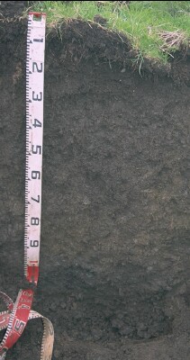 SW37 Profile |
| Subsoil | |||
| B21 | 25-60 cm | Very dark brown (10YR2/2); medium clay; strong coarse blocky, parting to strong medium blocky structure; very firm consistence moist; pH 5.5: | |
| B22 | 60-95 cm | Dark greyish brown (10YR4/2) with dark yellowish brown (10YR4/4) mottles; medium heavy clay; strong fine lenticular, parting to strong very fine lenticular structure; weak consistence moist; pH 5.8; wavy change to: | |
| B23 | 95+ cm | Very dark grey (10YR3/1) with yellowish brown (10YR5/6) mottles; medium heavy clay; strong fine lenticular, parting to strong very fine lenticular structure; weak consistence moist; pH 5.5. |
Key Profile Features:
- Clay texture throughout the soil profile.
- The profile will display significant shrinking and swelling during wetting and drying cycles. Strong cracking will occur due to shrinking.
Soil Profile Characteristics:
pH | Salinity Rating | |||
Surface (A1 horizon) | Strongly Acid | Low | Non-Sodic | None |
Subsoil (B21 horizon) | Strongly Acid | Very Low | Non-Sodic | None |
Deeper Subsoil (at 95+ cm) | Strongly Acid | Very Low | Non-Sodic | None |
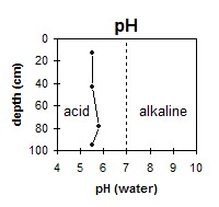 The whole profile is strongly acid. | 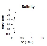 The salinity rating is low to very low throughout the profile. | 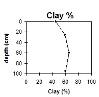 The clay content remains fairly constant throughout. |
Horizon | Horizon Depth (cm) | pH (water) | pH (CaCl2) | EC (dS/m) | Exchangeable Cations | |||
Ca | Mg | K | Na | |||||
meq/100g | ||||||||
A1 | 0-25 | 5.5 | 4.9 | 0.18 | 11 | 3.1 | 0.4 | 0.2 |
B21 | 25-60 | 5.5 | 4.7 | 0.1 | 3.7 | 5.5 | 0.2 | 0.3 |
B22 | 60-95 | 5.8 | 4.8 | 0.1 | 2.9 | 7.4 | 0.2 | 0.8 |
B23 | 95+ | 5.5 | 4.6 | 0.13 | 2.5 | 6.9 | 0.2 | 1.3 |
Horizon | Horizon Depth (cm) | Acidity meq/100g | Oxidisable Organic Carbon % | Total Nitrogen % | Field Capacity pF2.5 | Wilting Point pF4.2 | Coarse Sand (0.2- 2.0 mm) | Fine Sand (0.02- 0.2 mm) | Silt (0.002- 0.02 mm) | Clay (<0.002 mm) |
A1 | 0-25 | 16 | 6.4 | 0.53 | 45.9 | 27 | 6 | 14 | 21 | 45 |
B21 | 25-60 | 2.6 | 0.18 | 43.1 | 25.1 | 2 | 10 | 25 | 59 | |
B22 | 60-95 | 44.8 | 25.3 | 1 | 7 | 22 | 66 | |||
B23 | 95+ | 42.7 | 23.3 | 2 | 11 | 21 | 60 |
Profile Described By: Mark Imhof and Austin Brown (June 1998).
© State of Victoria (Agriculture Victoria) 1996 - .

This work, Victorian Resources Online, is licensed under a Creative Commons Attribution 4.0 licence. You are free to re-use the work under that licence, on the condition that you credit the State of Victoria (Agriculture Victoria) as author, indicate if changes were made and comply with the other licence terms.
The licence does not apply to ‘branding’ or some ‘images or photographs’ that may be owned by third parties. We ask you to seek prior approval to use images using the VRO feedback form. Access to higher quality images can also be provided on request.
This page was last updated on .