
SW31
Location: Gerangamete
Australian Soil Classification: Bleached-Mottled, Mesotrophic, Brown KUROSOL
Map Unit: Barongarook Land System (Pitt, 1981).
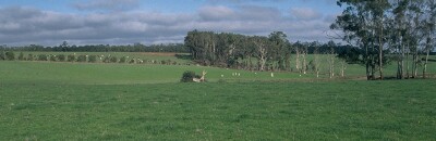
General Landscape Description: Crest of gently undulating rises.
Site Description: Grazing paddock (dairy).
Native Vegetation: Messmate (Eucalyptus obliqua) occurs on higher ground and Ribbon Gum (E. viminalis) and Swamp Gum (E. ovata) occurs on lower ground.
Geology: Tertiary - Moorabool Viaduct Formation.
 SW31 Landscape |
Soil Profile Morphology:
Surface Soil
| A1 | 0-15 cm | Greyish brown (10YR3/2); light fine sandy clay loam; weak coarse blocky structure; very firm consistence moist; pH 4.8: | 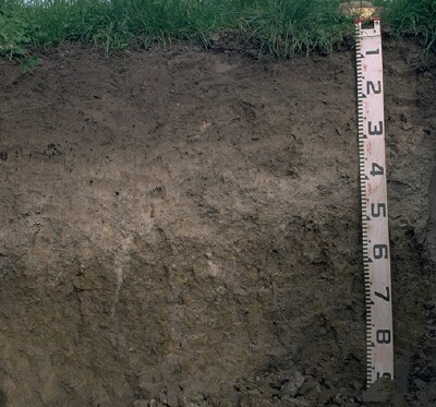 SW31 Profile |
| A21 | 15-30 cm | Dark brown (7.5YR3/2); very fine sandy clay loam; weak coarse blocky structure; firm to very firm consistence moist; pH 4.8: | |
| A22 | 30-40 cm | Greyish brown (10YR5/2), conspicuously bleached; very fine sandy clay loam; very firm consistence moist; pH 4.7: | |
| A23 | 40-50 cm | Greyish brown (10YR5/2) with brownish yellow (10YR6/6) mottles, conspicuously bleached; heavy very fine sandy clay loam; very firm consistence moist; pH 4.7; abrupt and wavy change to: | |
| Subsoil | |||
| B21 | 50-70 cm | Brown (10YR5/3) with yellowish brown (10YR5/6) mottles; light medium clay; moderate medium prismatic, parting to strong coarse blocky structure; strong consistence moist; pH 4.7: | |
| B22 | 70+ cm | Greyish brown (10YR5/2) with yellowish brown (10YR5/6) mottles; medium clay; moderate coarse prismatic, parting to moderate coarse blocky structure (with strong fine blocky structure in patches); strong consistence moist; pH 4.8. |
Key Profile Features:
- Strong texture contrast between (A) horizons and subsoil (B21) horizon.
Soil Profile Characteristics:
pH | Salinity Rating | |||
Surface (A1 horizon) | Very Strongly Acid | Moderate | Non-Sodic | None |
Subsoil (B21 horizon) | Very Strongly Acid | Very Low - Low | Non-Sodic | None |
Deeper Subsoil (at 70+ cm) | Very Strongly Acid | Very Low - Low | Non-Sodic | None |
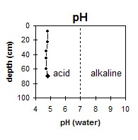 The whole profile is very strongly acid. | 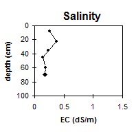 The surface has a moderate salinity rating. The subsoil is very low to low. | 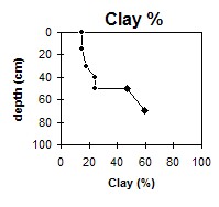 The clay content increases abruptly at 50 cm depth. |
Horizon | Horizon Depth (cm) | pH (water) | pH (CaCl2) | EC (dS/m) | NaCl % | Exchangeable Cations | |||
Ca | Mg | K | Na | ||||||
meq/100g | |||||||||
A1 | 0-15 | 4.8 | 4.3 | 0.26 | 0.02 | 5.1 | 0.4 | 0.6 | 0.05 |
A21 | 15-30 | 4.8 | 4.4 | 0.38 | 0.04 | 5.9 | 0.6 | 0.3 | 0.05 |
A22 | 30-40 | 4.7 | 4.2 | 0.24 | 1.2 | 0.2 | 0.3 | 0.05 | |
A23 | 40-50 | 4.7 | 4.1 | 0.14 | 0.8 | 0.7 | 0.3 | 0.05 | |
B21 | 50-70 | 4.7 | 4.1 | 0.19 | 1.5 | 2.7 | 0.3 | 0.05 | |
B22 | 70+ | 4.8 | 4.1 | 0.18 | 0.8 | 3.1 | 0.1 | 0.3 | |
Horizon | Horizon Depth (cm) | Acidity meq/100g | Oxidisable Organic Carbon % | Total Nitrogen % | Field Capacity pF2.5 | Wilting Point pF4.2 | Coarse Sand (0.2- 2.0 mm) | Fine Sand (0.02- 0.2 mm) | Silt (0.002- 0.02 mm) | Clay (<0.002 mm) |
A1 | 0-15 | 5.3 | 0.36 | 36 | 11.6 | 5 | 37 | 30 | 15 | |
A21 | 15-30 | 5.1 | 0.31 | 35.9 | 11.2 | 4 | 38 | 30 | 15 | |
A22 | 30-40 | 31.1 | 7.7 | 3 | 42 | 35 | 18 | |||
A23 | 40-50 | 25.3 | 9.2 | 3 | 40 | 33 | 24 | |||
B21 | 50-70 | 12 | 34.7 | 19.3 | 1 | 28 | 24 | 47 | ||
B22 | 70+ | 43.3 | 24.8 | 1 | 19 | 20 | 59 |
Profile Described By: Mark Imhof and Austin Brown (June 1998).
© State of Victoria (Agriculture Victoria) 1996 - .

This work, Victorian Resources Online, is licensed under a Creative Commons Attribution 4.0 licence. You are free to re-use the work under that licence, on the condition that you credit the State of Victoria (Agriculture Victoria) as author, indicate if changes were made and comply with the other licence terms.
The licence does not apply to ‘branding’ or some ‘images or photographs’ that may be owned by third parties. We ask you to seek prior approval to use images using the VRO feedback form. Access to higher quality images can also be provided on request.
This page was last updated on .