
Landslides
Corangamite Land & Water | Landslide Risk Assessment | Landslides - Simpson area | Landslides - Otway area | Landslides and Erosion report
This section has been developed in association with Peter Dahlhaus, University of Ballarat.
The term landslide is usually defined as: “the movement of a mass of rock, debris or earth down a slope”. This international definition is used by the Australian Geomechanics Society and includes all forms of movement from debris creep to rock falls. The terminology used to describe a landslide depends on the information known about the processes and generally uses two nouns to describe material involved and the style of movement, e.g. a rock fall or a debris flow.
The landslide material is classified as either ‘bedrock’ or ‘engineering soil’. Engineering soils are further subdivided into either debris (predominantly sand, gravel, cobbles and boulders) or earth (predominantly silt and clay). The five main types of movement are falls, topples, slides, spreads and flows.
Landslides have been a regular event in the natural evolution of landscapes in the Corangamite Region over the past several million years. They occur as one of the principal processes of landscape development. The main function of a landslide is the removal of Earth materials during the formation of valley and coastlines. These processes are still operating in those parts of the region that are being worn down by the actions of streams and rivers, and the eroding coastline.
| Over 1 400 landslides have been mapped in various studies within south west Victoria and it is estimated that thousands more, of varying sizes, exist. All mapped landslides occur south of the western Victorian volcanic plain, where the geology, steeper terrain slopes and climate combine to provide the conditions required. Areas where landslides are more prolific include the south-eastern slopes of the Otway Range; the slopes of the Barwon River valley and Gellibrand River valley; the Heytesbury region. Landslides vary in area from a few square metres to over 120 hectares and in volume from a few cubic metres to over ten million cubic metres. They are triggered by prolonged and/or intense rainfall, man-made changes to the landscape and rare earthquake events. The vast majority of landslides occur in two rock types, viz: the Otway Group rocks and the Gellibrand Marl. |
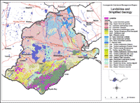
The Otway Group rocks are mostly sandstones and mudstones, made up of fragments of volcanic rocks, calcic feldspars and very little quartz. These minerals that make up the rocks are quickly and easily weathered when exposed to the elements (except quartz), producing a clay-rich soil. The Otway Group is regarded as the most landslide-prone of the geological units in south west Victoria. Landslides occur in both the rock and soil materials, even where the rock is not significantly weathered. Among the other geological units, the Narrawaturk Marl and Gellibrand Marl are also landslide-prone. These marls were deposited in the Otway Basin as the seaway opened up between Antarctica and Australia in the final breakup of Gondwanaland.
Landslide examples
Very few landslide events in south west Victoria have been usefully documented in the historical record and only a few have been investigated in detail. Examples of various mechanisms and styles are provided below:
Lake Elizabeth, 1952
Lake Elizabeth was formed by the largest documented landslide, which occurred in late June 1952. The failure occurred following the wettest monthly rainfall on record. The landslide involved approximately six million cubic metres of rock, with a surface area of about 48 hectares.
The slide formed a dam about 35 metres high and 400 metres wide that blocked the East Branch of the Barwon River, to form a lake. Failure occurred along the bedding planes, which dip at 12o to 20o towards the river. During the three days prior to the landslide exceptionally heavy rainfall was recorded at Pennyroyal (242 mm) and Tanybryn (587 mm), the two closest rainfall monitoring stations. In fact, June 1952 remains the wettest month recorded at each station. Regionally, high rainfall was recorded for 1951, 1952 and 1953.
On the 5th August 1953 the lake overflowed causing the top 26 metres of the landslide dam to fail and a wall of water and mud passed down the river. An eyewitness to the flood reported that it was accompanied by a terrific roar and vile smell, and overtopped the seven-metre (25 feet) high railway bridge at Barwon Downs. Damage was reported to fencing, and an extensive one-metre layer of silt was deposited over paddocks. Many farms were reported as financially ruined, as some had over 20 hectares of dairy pastures under silt. Significant damage was sustained to roads and bridges as far downstream as Birregurra. No damage to dwellings or personal injury was reported.
Wild Dog Road, 1952
A landslide occurred at the junction of Wild Dog Creek and Busty Roads, near the town of Apollo Bay, during June 1952. The landslide was triggered by heavy rainfall. Apollo Bay records the total rainfall for June 1952 as 295.4 mm (mean monthly is 108.9 mm) and total rainfall for 1952 as 1599.5 mm (mean annual is 1053.7 mm).
The rock mass failed over a 390 metre section of the slope and the debris flow travelled another 410 metres downhill to block Wild Dog Creek. The dam resulted in some local flooding and deposition of an alluvial terrace. Drilling revealed that the 9 metre thick depositional fan at the Creek level had been deposited over several events. The landslide debris continued to fail up until the 1980s and is still considered active.
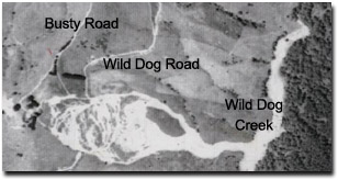 An aerial photo of the 1952 landslide at the junction of Wild Dog Creek Road and Busty Road. | 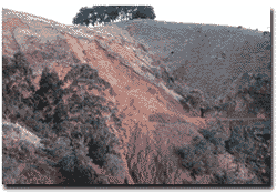 The 'big slide' on Wild Dog Road in September 1979. This is an active landslide which extends over approximately 16 hectares and fails in most wetter years, blocking the road and disrupting traffic. Photo: Gil Medwell. |
Windy Point, 1968-1971
The rock structure in the vicinity of Windy Point, on the Great Ocean Road near Lorne, is among the least stable along the coast. The thick, jointed sandstone stratum is underlain by two thin (12 cm and 40 cm) silty clay beds that dip seaward at about 27o to outcrop from the natural slope at road level.
The Windy Point Rockslide commenced with the removal of a relatively minor quantity of rock during road maintenance in late 1968. Several subsequent minor rock slides followed and evidence of larger scale movement was observed up to 70 metres above road level. During 1970 and 1971 the rate of movement increased to a maximum of 2 cm per day and a mass of about 3 000 tonnes began sliding towards the road.
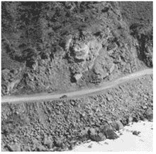 Windy Point. An aerial oblique of the Windy Point rockslide just south of Lorne. This photo appears in "Introducing Victoria's Geology" (Geological Society of Australia - Victorian Division). | Above the slide, up to 150 000 tonnes of sandstone, in large and small discrete blocks, was moving down dip on the silty clay slip planes. Some shear failure occurred in the sandstone, fissures and joints opened to depths over 15 metres and the surface soil was extremely fissured. The Great Ocean Road was closed in July 1971. A cable anchoring system was designed and the contractor commenced work in September. Movement ceased after the first seven anchors were tensioned in October, even though heavy rainfall was falling at the time. The road was re-opened in December 1971 after the installation of several more anchors. |
Simpson - Princetown Road, 1972 - present
This landslide occurs within the Heytesbury Region, on a low-angled slope (~6o) on the Gellibrand Marl. The slide was initiated in the early 1970s, probably 1972, as a small failure at the foot of the slope adjacent to an incised drainage line. The small failure led to a larger progressive failure that culminated in a shallow translational landslide about three hectares in area, which destroyed some farm buildings and part of a main road during 1980. Although the 1980 failure occurred during the seasonally wet months of the year, the recorded rainfall was approximately equivalent to the monthly average. Movement had ceased during by the late 1980s following the installation of a deep drain, however movement has recommenced during 2000-2001 and has resulted in the evacuation and removal of the farm house and further damage the main road. Although the movement is generally triggered by rainfall, the recent activity has occurred during lengthy period of below average rainfall.
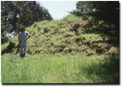
This photo shows Tony Miner standing at the toe of
the Princetown landslide. This landslide has been
responsible for the destruction of a dairy farm,
including the house and farm buildings. It occurred
in the Gellibrand Marl on a slope of around 10 degrees.
© State of Victoria (Agriculture Victoria) 1996 - .

This work, Victorian Resources Online, is licensed under a Creative Commons Attribution 4.0 licence. You are free to re-use the work under that licence, on the condition that you credit the State of Victoria (Agriculture Victoria) as author, indicate if changes were made and comply with the other licence terms.
The licence does not apply to ‘branding’ or some ‘images or photographs’ that may be owned by third parties. We ask you to seek prior approval to use images using the VRO feedback form. Access to higher quality images can also be provided on request.
This page was last updated on .